Change is on the Way

November 19, 2012

Break out the shorts for Thanksgiving, winter coats are just around the corner. High temperatures this time of year normally range from the mid-40s in eastern Nebraska to the low 50s from central Kansas to eastern Missouri. Temperatures this week are nowhere near normal with highs soaring into the upper 60s and even 70s in some locations.

If you’ve lived in the Midwest during the winter (last winter doesn’t count), you know the weather scales can tip quickly. Indeed they have already done so this fall (as you can see here).  It does look like temperatures will briefly dip after Thanksgiving. However, a much more impressive swing could be in store for the end of the month.

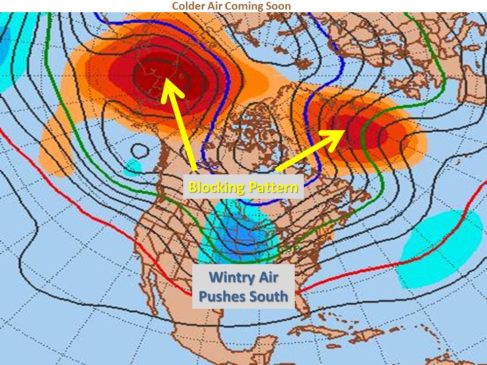
There are many factors meteorologists can look at in determining when the next cold air outbreak may occur in our region.  One of these factors is high latitude blocking. When high pressure forms over the high latitudes, cold polar air can be blocked southward into our area.  Mid-range forecast models are coming into agreement that a strong blocking pattern will set up over the north Atlantic and north Pacific by the 27th or 28th of November, sending our temperatures plunging by the end of the month.

There are also signs that a storm may try to develop over the western U.S. around that same time.  Depending on the track and timing of that potential system, wintry weather could be in store somewhere in our region for the end of the month into early December. No matter when changes come to the Midwest, W.O.N’s meteorologists will be notifying clients well ahead of time.


“Guess the Snowiest Winter Day Contest”

Winter Contest Poster


Here’s your chance to win a tablet computer and accessories!!!

Enter Weather or Not’s 2012-13 Winter Snow Contest by submitting your guess for the date and amount of the largest snowfall in any of Weather or Not’s regional cities!

Submit your entry by emailing info@weatherornot.com with the subject:  2012-13 Winter Snow Contest

Your entry must include your name, snowiest date and snowfall amount for any of the regional cities within Weather or Not’s region (see map below for details).


EXAMPLEName:  Jane Doe – Date:  November 3rd – Snowfall Amount: – 16″


Entries must be received by November 1, 2012.  Limit of one (1) entry per person.  Employees and immediate family members of employees of Weather or Not, Inc. are not eligible to enter.  Winner is decided by the entry closest to the date (Midnight-Midnight) when the most snow falls as determined by the climatological station at any of the following cities: in Nebraska, Omaha; in Kansas: Salina, Manhattan, Topeka or Lawrence; in Missouri: St. Joseph, Kansas City, Springfield, Columbia or St. Louis.  Period of the contest is November 1, 2012 to April 15, 2013.  Winner will be announced here, as well as on our Facebook and Twitter by April 30, 2013.  In the event of a tie for the closest day, the entry closest to the actual measured amount of snow will determine the winner.  Employees of the Company and members of their immediate families  are not eligible to participate and win.


What will be the snowiest day in a Weather or Not Regional City?

Snow Contest Cities


Winner will receive a tablet computer and accessories.

Play Today!


Severe Weather: Not Just a Spring Thing

October 12, 2012

Severe weather threats including tornadoes are the big topic this weekend in the Midwest.  Many businesses are readying their operations for snow and winter these days.  However, this weekend, heavy rain, damaging winds and tornadoes could challenge many jurisdictions throughout the Heartland.

Why now?

Mistakenly, many people think there is a designated “severe weather season,” primarily because many of the most devastating tornadoes occur from March-June.  Tornado watches and warnings, and tornadoes for that matter, have happened in every month of the year.  Most recently, the St. Louis Metro had multiple tornadoes on December 31, 2010 including an EF-3 during a New Year’s Eve outbreak that included 24 tornadoes in Missouri.

Weather 101 tells us that weather is created by the atmosphere trying to balance itself. If the earth had its way, there would be consistent temperature, pressure, etc. The wind is the atmosphere’s fight to bring the earth to an equilibrium and that is why the bigger the differences, the bigger the storm.  When the warm Fall temperatures are mixed with moisture and colder, drier air pushing down from the north a fight ensues in the form of wind.  Add the right combination of instability and wind shear and you could be spotting tornadoes.

For Saturday, all of those ingredients should be in play for the Heartland.  Please stay alert to emergency messages, or sign up for a free trial of A+ Weather Alerts.  Weather or Not’s staff of meteorologists will be keeping our clients ahead of the storm  24/7.


Another October Freeze?

October 10, 2012


This week’s seasonal temperatures are courtesy of a transitional ridging pattern out West. The good news is that the southern jet stream could actually bring in moisture during this transitional period, October 13th-17th, offering us the best rain potential we’ve seen in awhile. Even severe weather could return this weekend.

Chilly weather returns for the latter half of the month, including Halloween, so enjoy the mild temperatures for the next week. As we head toward the end of the month, a deep trough will set up and looks to dominate the weather pattern across the eastern two-thirds of the country. This northwesterly flow leads to cooler conditions across the Midwest and Southeast. The much talked about El Niño remains weak with little effect on the overall pattern.

Late October Forecast

For the Heartland expect below normal temperatures from the 17th through the end of the month, as we will continue to have numerous cold fronts diving through the area. This will also lead to quick hitting rain chances, if we can squeeze out any moisture.


2012 APWA Snow Training Expo

October 10, 2012


Training professionals improves efficiency and expertise. It’s the best way to save money and improve safety. That’s why cities and counties throughout the region sent their drivers to the 25th Annual Snow and Equipment Training Expo last week. It’s an excellent investment!


How reliable are your emergency communication methods?

September 26, 2012

Clear communications are critical to managing emergencies.  Earlier this year, Weather or Not owner Sara Croke co-wrote a very informative article for the APWA Reporter (read more) about the reliability of different communication tools and how first responder’s should be prepared to have redundancy built into their communication plan during the course of a disaster.

What about your small business?  Your communication plan needs to be very comprehensive and far reaching too.  First and foremost your communication plan should include a strategy to communicate with your employees and their families.  From that point, your list of audiences cover a large group of people and each of these groups will need to be addressed during the course of an emergency.


(Courtesy of FEMA)

For more information about developing your plan contact Weather or Not President, Sara Croke.  Sara will speak with your managers about how to develop a plan for your specific business needs.  Call 913-722-3955 or 800-996-7668 today, so your business is ready when the next disaster strikes.


Missouri Spells Relief: I-S-A-A-C

September 6, 2012

Released this morning, the National Drought Monitor downgraded most of Missouri from either “extreme” or “exceptional” to “severe” drought.  The remnants of Hurricane Isaac provided much needed relief!

Missouri Drought Monitor - August 28

Missouri Drought Monitor – Aug. 28, 2012

Missouri Drought Monitor Sept. 6, 2012

Dragging northward, this tropical air mass brought significant rainfall to the entire state with totals ranging from 1.43″ in Farmington, MO to 6.52″ in Edina, MO. The deluge felt by many over the weekend was enough to take a major bite out of our rainfall deficits. However, the drought monitor shows we still have a way to go before total relief is felt.


Some of the winners in the rainfall lottery were:

Edina – 6.5 inches

Independence – 6.2

Lee’s Summit – 5.6

Mexico – 5.2 inches

Kansas City DT – 4.9

Centralia – 4.7 inches

Fenton – 3.4 inches


September is National Disaster Preparedness Month

September 4, 2012

Did hurricanes prompt the choosing of September as National Preparedness Month?  Actually, the tragedy of 9/11 reminded us all that survival preparations could be needed at a moment’s notice.

Improving disaster preparedness and response is the purpose of the 9th Annual National Preparedness Month.


Pledge to Prepare:  Awareness to Action

  1. Develop a communications plan.
  2. Learn about emergency hazards and appropriate responses.
  3. Build an emergency kit.
  4. Get involved in preparedness in your community

Throughout September, we will be sharing emergency preparedness lessons learned that will help your operation be ready for the next disaster. We would like to hear your strategies or answer your questions. Please leave us a comment or e-mail us!


Is your business ready to shift gears as quickly as the RNC?

August 28, 2012

The Republican National Convention had extensive plans in the works for more than a year; speakers, media coverage, travel arrangements, catering, venue preparations, etc.  Hurricane Isaac made them scramble behind the scenes.  Organizers adapted quickly, and then publicized their changes clearly.  Decisive action kept participants directly on track and far from any behind-the-scenes chaos.

How will your event operations handle disruptions when weather threatens?  What can you do to:

  • Mitigate revenue loss
  • Maintain customer participation
  • Keep workers focused
  • Utilize public relations

Max Whittaker/The New York Times

SOLUTIONS

Create a Deadline:  How much time will be needed for effective, calm action? The RNC couldn’t wait for the tropical storm to arrive before they took action.  Use what you know about your business to create options ahead of time.

Deposits:  What non-refundable money can you reasonably require?

Rain Insurance This policy may cover mandatory costs such as entertainment or your deposits.  If you can’t make money at least try not to lose any!

Social & Traditional Media:  Get the word out ASAP!  Many had heard that the RNC cancelled two days of convention activities before they had ever started following Isaac.

Before any event, prioritize its purpose.  What’s the critical “Take Away”?  Identify the activities that directly support your objectives and create the most flexibility for executing them.  That way, when an emergency disrupts the original plan, viable options will be handy.

Being a leader, whether it’s hosting a celebratory event or a strategic national planning meeting, is a very Darwinian role.  Adaptability = Success.  Having your goals, priorities and options identified ahead of time will create a seamless success for participants and ultimately maximize your bottom line.

As we’re seeing this week, nothing changes faster than the weather.  Weather or Not works with companies, government agencies and airports 24/7.  Our clients have plenty of time to adjust their operations, thereby maximizing benefits while minimizing budgets.


What Action Will Your Business Take?

Lessons Learned: A series of lessons learned from past disasters. Weather or Not will highlight one topic each month to help you prepare for severe storms.

Businesses and organizations encounter unique challenges as they devise the most successful preparedness action plan for their employees and patrons.  President, Sara Croke explains the questions companies should be asking to give them plenty of time to act when disaster threatens their business in the current issue of Thinking Bigger Media.