Three-Day Weekend – Third Day’s a Charm

LaborDayWeekend

August 30, 2013

Conditions start out hot as the KC Irish Fest heats up this weekend. Saturday will be the hottest of the weekend with highs in the upper 90s, almost no breeze and heat indices in the low 100s. So find the shade, drink plenty of water, and take it easy as you enjoy all that this year’s Irish Fest has to offer.

Temperatures and humidity begin decreasing on Sunday as a cold front approaches, so outdoor events will be slightly more bearable. We’ll have to watch for an isolated shower or thunderstorm Sunday morning, but it will not be enough to dampen the Irish spirit. Real relief finally arrives on Monday as a cold front ushers in mid-80s and low humidity. That should give the hard-working volunteers a great day to spend in a hammock!


Kansas City Forecast:

KCForecast


APWA Congress – Chicago Weather Planner

August 23, 2013

Summer Returns for APWA Congress

Last summer’s scorcher is a distant memory as cool and comfortable conditions have dominated this summer in the Central US.  The improvement has been thanks to a persistent trough of low pressure nudging southward from the Great Lakes.

Unfortunately, the weather pattern is about to remember what season it is, as a late August ridge of high pressure quickly builds across the nation’s mid-section.  This transition is expected to heat Chicago’s highs into the upper 80’s and low 90’s just in time for the Best Show in Public Works.  Of course, McCormick Place will always be cool for education sessions and the expo.

There could be a little rainy relief Tuesday into Wednesday, but at this point any showers or thunderstorms look few and far between.  Check out forecast below as you prepare for a fun and informative time with all your APWA colleagues in Chicago.

Don’t forget to plan some time with Weather or Not’s own Sara Croke.  She’s looking forward to catching up with you and hearing how our team of meteorologists can continue helping you save money and improve safety.


DEFINE WINDY CITY

August 23, 2013

Windy City

APWA members are descending on Chicago this weekend for the 2013 APWA International Congress.  While visiting they might hear Chicago referred to as the
Windy City.  Chicago’s yearly average wind speed is only 10.3 mph which doesn’t even place it in the Top 10 for Metropolitan areas (greater than 1 million people).

In fact, Kansas City has a higher average wind speed than Chicago at 10.6 mph. And FYI, St. Louis has an average wind speed of 9.6 mph. So, who could really be declared the windiest city? Take a look at the list below.

Windiest Metropolitan Areas (Greater than 1 million people)


City

MPH

Boston, MA 12.3
Oklahoma City, OK 12.2
Buffalo, NY 11.8
Milwaukee, WI 11.5
Dallas, TX 10.7
Kansas City, MO 10.6
San Francisco, CA 10.6
Cleveland, OH 10.5
Minneapolis, MN 10.5
Virginia Beach, VA 10.5
Providence, RI 10.4
Chicago, IL 10.3
Detroit, MI 10.2

Would you like to intern at Weather or Not?

Laren1

Steve Irwin and Laren Mahoney

August 7, 2013

Meet Laren Mahoney, another one of the summer interns here at Weather or Not. Laren begins a master’s program in atmospheric science at Creighton University in the fall. She spent the past decade in public relations before getting a degree in engineering.  Laren met Sara Croke, owner of Weather or Not, through Kansas City’s Irish community and began interning last winter on the mid-morning shift.

“From this internship, I’m walking into my master’s program with operational forecasting experience that will put me ahead in my classes and further ahead of graduates without experience.” said Laren. “I was able to help create daily weather forecasts, ozone forecasts and work on projects that significantly benefit Weather or Not.”

Are you an energetic learner who’d like to participate in our paid internship this fall semester? If so, e-mail our Weather Center Manager, Brian Koochel at brian@weatherornot.com.

Enjoy grad school, Laren!


August Off to a Wet Start for Some

August 6, 2013

If you get a break in your water bill this August, you can thank a phenomenon called the low-level jet stream.  The low-level jet stream forms during the overnight and early morning hours due to a temperature difference between the Rockies and the Plains.  For example, some locations in central Colorado dropped into the mid 40s last night, while mid 70s to low 80s were common across the Plains.  This gradient in temperature causes a fast-moving stream of air to develop about 5000 feet above the surface called the low-level jet stream.  This stream of air is responsible for much of the overnight and early morning thunderstorms we see during the summer.

Current Pattern 8-6-13

Right now portions of Kansas and western Missouri are stuck in a pattern where the low-level jet stream is nearby just about every night, meaning the rain just keeps on coming.  Many locations in southeast Kansas and southern Missouri need the rain to stop, as 5-10 inches of rainfall in the last 7 days continues causing episodes of flash flooding.

Radar estimated rainfall over the past 7 days

rain

Wet August Continues

Unfortunately our current weather pattern is nearly stationary, so wet conditions and areas of flash flooding will most likely continue on and off through at least next week. 


Are you an energetic learner who’d like to participate in our paid internship this Fall semester?

August 1, 2013

IMG_0002_web

Meet Carly Cassady, one of our summer interns at Weather or Not. We are certainly going to miss her as she returns to the University of Memphis, where she is studying Earth Science and Geography. A Division 1 soccer player, Carly’s career goal is Broadcast Meteorology. She read about our company in the KC Star article explaining how Weather or Not kept an eye on the sky for the Royals’ grounds keeping crew during the 2012 MLB All-Star game.

“I learned about what really goes on in an active weather center, from analyzing models to seeing what goes into creating a forecast”, said Carly. “I also really enjoyed the research and verification projects I was assigned to.” We really appreciated Carly’s efforts. Projects moved faster with Carly on the team, and we’re not just saying that because she brought delicious tornado, lightning and sun cookies!

Are you an energetic learner who’d like to participate in our paid internship this Fall semester? If so, e-mail our Weather Center Manager, Brian Koochel at brian@weatherornot.com.

Good luck this semester, Carly!


Weather or Not, Inc. helps Solar Impulse make history

June 13, 2013

Across America 2013: 3rd leg from Dallas Fort Worth to Lambert - St. Louis. Solar Impulse HB-SIA being secured inside mobile hangar © Solar Impulse |Revillard| Rezo.ch

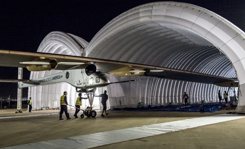
Across America 2013: 3rd leg from Dallas Fort Worth to Lambert – St. Louis. Solar Impulse HB-SIA being secured inside mobile hangar © Solar Impulse |Revillard| Rezo.ch

Solar Impulse is making a historic flight across the United States as the first manned plane to fly for 24 hours on nothing but solar-powered batteries. With a stop-over in St. Louis, officials at Lambert St. Louis International Airport recommended Weather or Not, Inc. to assist with their weather-related needs.

“We are proud to be a part of this groundbreaking project,” said Sara Croke, president of Weather or Not, Inc. “We’re providing the team with detailed forecasts, up-to-the-minute rain updates and allowing them to have 24-hour access to our team of meteorologists. If there are any weather issues on the St. Louis leg of their trip, they will be well cared for.”

Piloted by Bertrand Piccard and Andre Borschberg, the Swiss-made Solar Impulse is flying through five stops from California to New York. Their goal to change minds and influence future generations about the strengths of solar power technology. They also believe the technologies used in the Solar Impulse could be used to reduce energy consumption in cars, lighting systems, electronics and cooling and heating systems.

Solar Impulse can fly day and night without fuel by the solar energy gathered from 12,000 silicon solar panels as thin as a human hair. This plane weighs only 3,500 pounds, about the same as a Honda CR-V, and has a 208-foot wingspan – larger than a 747’s. You can find more information about the plane and its journey at www.solarimpulse.com.


Effects of Humidity

High Temperatures - May 14, 2013

High Temperatures – May 14, 2013

When temperatures reached the low 90s in Kansas City yesterday, most of us feared we’d be sweltering. After lows in the 30s, we weren’t ready for the 90s!

Yet last evening was downright comfortable: golfer’s smiled, gardeners were ecstatic and few air-conditioners were turned on.

Today it’s nearly 10 degrees cooler but feels less comfortable. What’s up with that? The dew point is what’s up.

Last night’s dew point in the 40’s made us completely forget about our high temperatures in the 90’s. Essentially, yesterday we got a taste of what people in the Southwest call “dry heat”. Since their thermometers read triple digits for months on end, let’s not sign up for that and be glad our “dry heat” day was relatively mild.


Spring . . . . . . . . A Tease or Here to Stay?

April 5, 2013

While the Easter Bunny (last seen fighting the Groundhog) was waiting for snow to melt before he began his deliveries, most of us were wondering, will winter ever end?  Although Nebraska and Colorado could see a round of April snow next week, the current pattern change makes it safe for most of us to store the shovels away.

A condition known as the negative phase of the North Atlantic Oscillation (NAO) is partly to blame for the cold air and snow that spilled southward in March.  Instead of winter snow and ice; spring rain and thunderstorms are heading our way.

Next week, the negative phase of the NAO will be weakened.  A long stretch of Pacific moisture (below) will be drawn into our area, bringing multiple rounds of rain and thunderstorms late Sunday through Thursday.  If strong winds aloft provide enough extra energy to the thunderstorms, severe weather could be around the corner too.

Rain and 50’s?  Severe and 70’s?  While it’s still too early to say, we do give a 100% chance that Weather or Not’s team of meteorologists will be advising construction crews, event managers, golf courses and ball-fields.  As always, your business is on our radar 24/7!


One for the Record Books!

March 25, 2013

Yesterday’s snow in St. Louis was one for the record books!  The snow that blanketed the region stands as THE highest calendar day March snowfall on record and the second highest calendar day of snowfall EVER.

StL_TopTenSnow_Day


For a 24-hour period, yesterday’s snowfall was ranked in the top 10, coming in at number 6 overall.

StL_TopTenSnow_24hr