


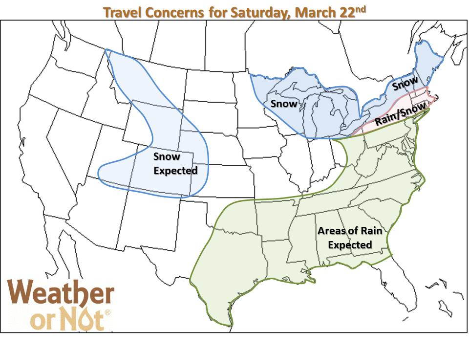
This is the FINAL update for Spring Breakers returning to the Midwest on Saturday.
While precipitation may occur, none of those shaded areas have blizzard or severe storms in the forecast.
This is the FINAL update for Spring Breakers returning to the Midwest on Saturday.
While precipitation may occur, none of those shaded areas have blizzard or severe storms in the forecast.
February 4, 2014
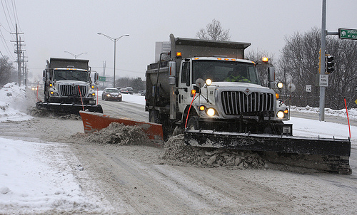
An excellent example of how to manage roads during a winter storm was witnessed in the Kansas City Metro today. With 6-10″ ISO 12″ coming down between 10am and 10pm, (heaviest 10a-6p) most schools and many businesses closed or allowed employees to work from home. This gave public works crews the opportunity to get their job done, creating safer travel sooner.
If you do have employees in today, we are advising you to tell them to “stay put” until the road crews make one more pass after the heaviest snow lightens up, after 6pm. Yesterday, Weather or Not alerted folks they should plan on staying a little later at the office tonight, ensuring the easiest, safest drive home possible. Realistically speaking, they’ll likely get home sooner by leaving later!
January 10, 2014
Winter swept into St. Louis on Dec. 5th starting with scattered sleet and freezing rain before turning to snow and piling up close to 4″ in parts of the metro. Since then, Mother Nature has dealt the entire metro blow after blow, culminating with the record breaking snows that started last weekend.
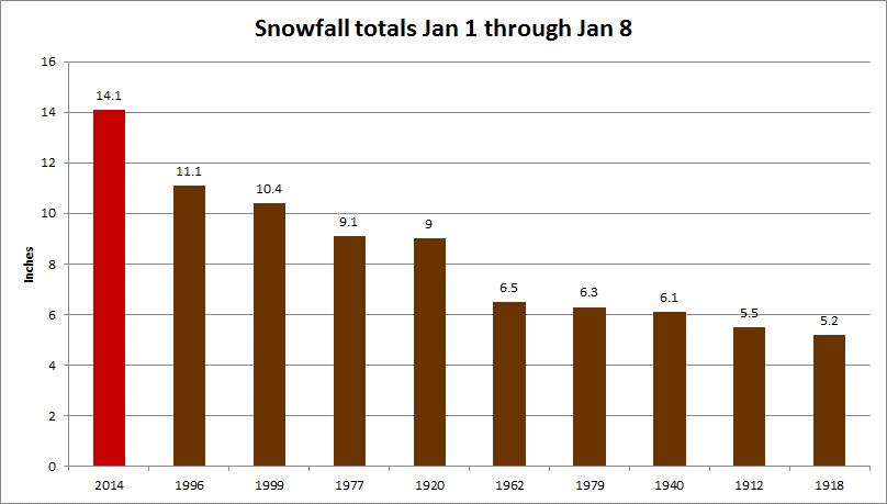
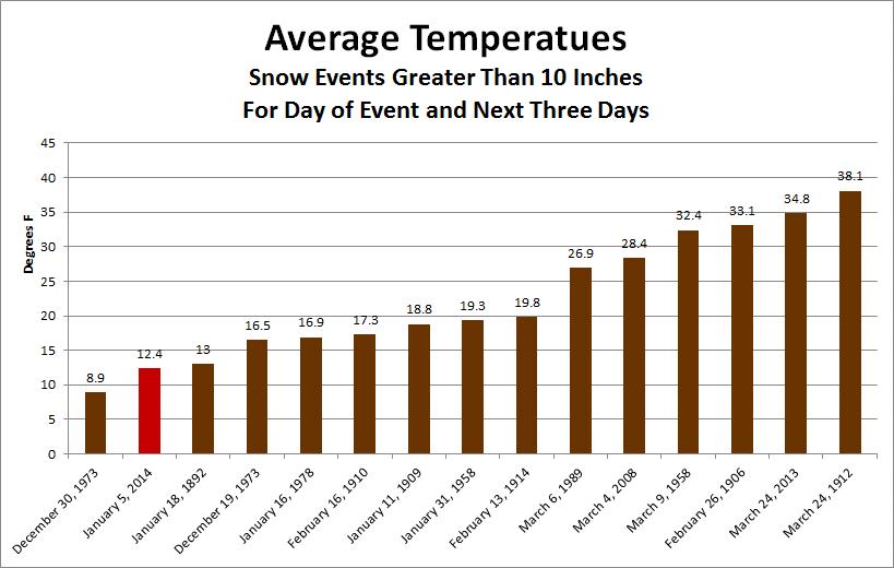
To make matters worse, January’s snow has been accompanied by extremely cold temperatures, resulting in even more headaches for anyone involved in snow removal. The January 5th event was the second coldest snow event, that exceeded 10 inches, in St. Louis history.
January 2, 2014
What would you do with an extra day or two of vacation? Wind chills ranging from -15 to more than -35 on Monday in Missouri and Kansas might be enough to cause concern for school officials.
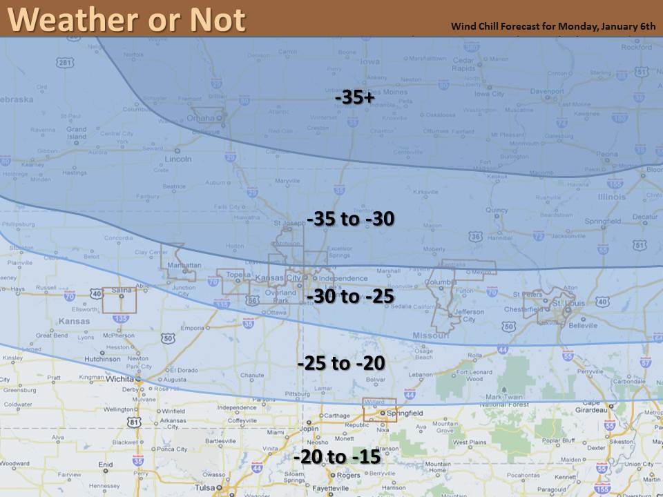
While the Arctic blast is a certainty, students and teachers should hold off making their plans until exact wind chills are known and they hear the official word.
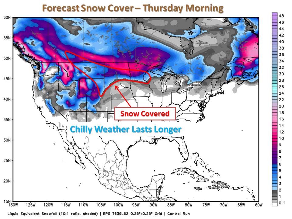
December 2, 2013
Today’s warm-up across the Central Plains is aided by a lack of significant snow cover. Our air is able to modify and warm-up more because of the bare ground in the “Arctic Blast’s Alley”. We’ve already had two major shots of cold air flow through that same “alley”.
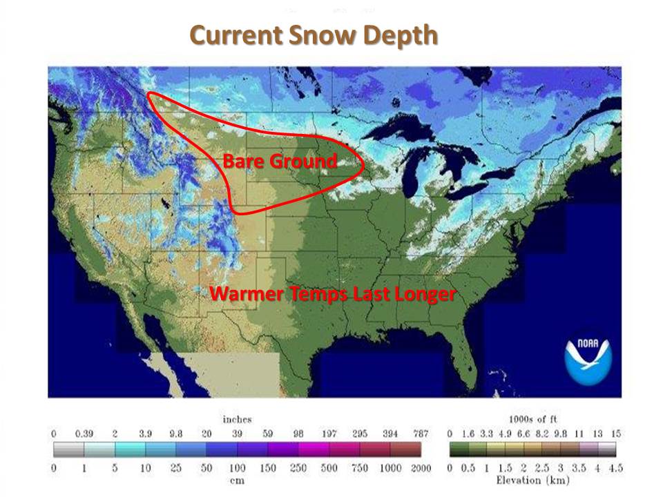
As we head through winter, this “alley” will likely become snow covered. Over the next few days, the Northern High Plains will get a good layer of snow. Air travelling over this route will have less bare ground, hence even colder air plunges into the Central Plains. Since the energy of any warm-up near our source of frigid air will be used to melt snow, we’ll stay colder longer.
So wrap up your outdoor activities and get ready for another taste of winter.
November 25, 2013

Professional meteorological services have been saving money and improving safety for businesses, road crews, schools and airports for decades. How can you tell the difference between a state-of-the-art, experienced operation and an individual at home playing on the internet? So when accuracy means money, answers to the following questions should help you match your operational needs with the experience that will serve you best.
 Facility managers, business owners, and even homeowners may be looking for a professional snow removal service to help manage winter weather. Here are a few general questions that can help you find the best snow removal service to match your needs:

The cost to keep Lambert-St. Louis International Airport’s runways plowed and operational during winter snow storms can seem astronomical; however, the costs could be much higher if not for the use of services provided by Weather or Not, a private weather service based in Shawnee, Kansas.
According to Bill Korte, Assistant Director of Operations and Maintenance at Lambert-St. Louis International Airport, “Our cost for outside contract plowing crews is $12,000 per hour [during a snowfall event].” Korte points out that the contract crews are necessary to augment their staff efforts to keep the airport open for the public’s travel convenience and so the airport can generate revenue.
For the past nine years, Lambert-St. Louis International Airport has relied exclusively on Weather or Not. Korte said that the forecast data and information Weather or Not provides is invaluable for their daily operations and is critical during snow storms. He also explained that public forecasts commonly available are too broad and weather conditions can vary widely across a large metropolitan area like St. Louis.
Korte discussed the massive blizzard that blanketed and paralyzed much of the Midwest and the State of Missouri on February 1, 2011. “The broadcast media and public weather outlets forecast 18-20” of snow for the entire St. Louis metro. Those forecasters also said it would start snowing nearly 24-hours earlier than it actually did. If we had relied on those forecasts, we would have scheduled and paid contract work crews to wait for hours that they didn’t actually work. Weather or Not’s forecast correctly told us that the airport would only receive about 6” of snow. And, they told us almost to the hour when the snow would begin,” Korte said. “So, we saved thousands of dollars because we knew when to schedule the contract work crews to show up!”
The beneficial labor savings to the airport exceeded $250,000 for this blizzard event because the airport had reliable weather information to make good business decisions.
Korte also said that the airport uses Weather or Not services year round. “We have to know if and when it is going to rain before we pour expensive concrete or apply asphalt patches. And, We utilize Weather or Not’s forecasts and mobile weather alerts to insure the safety of our crews.” Korte remarked, “We trust Weather or Not to give us accurate weather information so we can do our jobs; and, trust is very important to us.”
 Congratulations to Kansas City International Airport crews who kept the airport open during blizzard conditions and Westwood Public Works who managed to clear roads with only a crew of 3.
September 5, 2013
Sunday morning was no time to wait for an official warning! Businesses, festivals, recreation facilities, and utilities often suffer damage by weather that does not meet official severe weather thresholds. Sunday morning (Sept. 1), several specific “nowcasts” gave our clients great lead-time. This is what Weather or Not does better than anybody else! Here’s an example of how that worked.
Weather or Not meteorologists called a city public works department, warning them to prepare for damaging wind gusts up to 60 mph, almost 30 minutes before an official severe thunderstorm warning was issued. The image below shows the damaging wind gusts moving through the area.

Sure enough, their public works crews were picking up debris so later that morning the local utility could get in and make repairs.
As strong storms moved farther south, Weather or Not meteorologists called another city at 6:15am telling them to expect widespread rain and thunderstorms with wind gusts of 30-50 mph to arrive at their festival site around 7:15am. This call occurred over an hour before an official weather statement was issued. The image below shows 30-50 mph wind gusts. We were able to give our clients the greatest lead-times possible, proving very helpful on a holiday weekend.

If accuracy and early warning matter to your operation, contact sara@weatherornot.com today and we will create a weather plan together!