


December 10, 2014
|


|
December 10, 2014
|
|
December 1, 2014
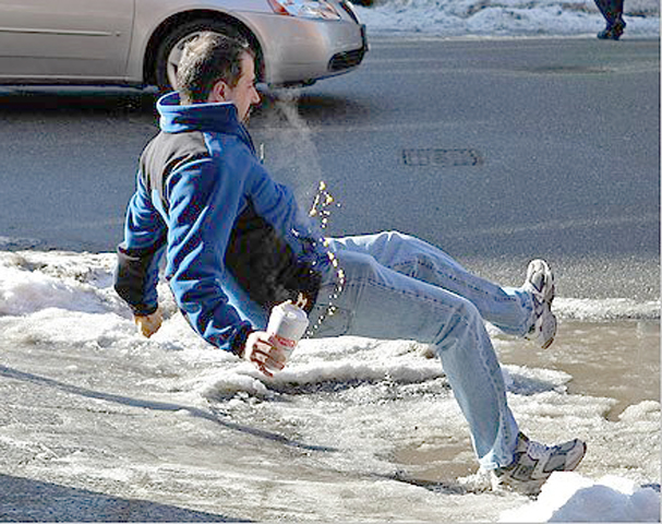 It doesn’t take much to cause major problems, as experienced in the St. Louis area this morning. Even light, scattered snow or rain on a frozen surface causes car accidents and slip and fall injuries. This is when private meteorologists prove most beneficial. We help you get your crews in position to make roads, sidewalks and parking lots as safe as possible.
Our clients were first alerted at 10:30 pm last night (Nov. 30th) of the approaching problems for Monday morning’s rush hour. They were updated numerous times by our meteorologists as pavement temperatures fell below the freezing point and problems began.
Weather is our business. Before it impacts yours, our meteorologists will provide the critical consulting your operation needs 24 hours a day, 365 days a year! Call us today at 913-722-3955 and tell us how we can help improve your profits and/or safety.
November 6, 2014
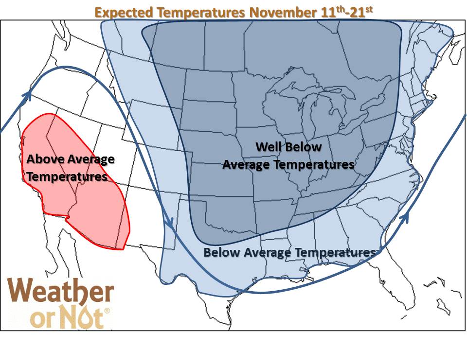
Below to well below-normal temperatures will rule November. For at least the next two weeks, waves of much colder air plunge into the Plains from the Arctic Circle. Several stretches of high temperatures struggling to reach 40 and lows dipping into the teens-low 20s will last roughly 4-6 days. A day or two of highs in the 50s to low 60s will be very hard to come by. This pattern looks pretty solid through the end of November. Even if the pattern moderates approaching Thanksgiving, we’ll still be below normal temp-wise just not shivering at the thought of going outside.
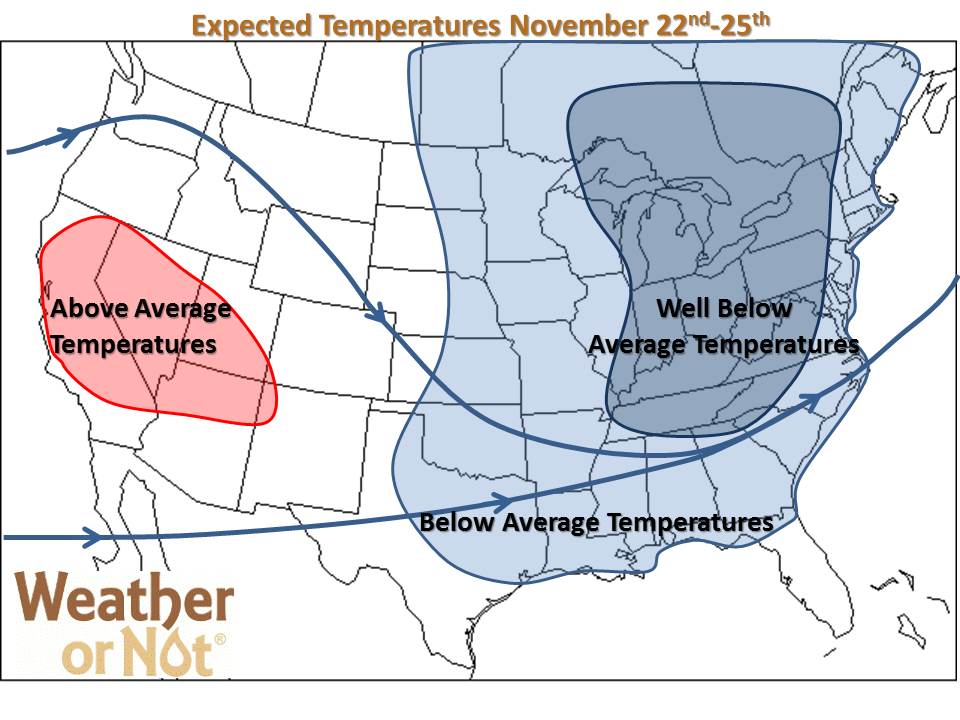
Since the air will be originating from Canada, there will be very little moisture in it. However, these strong fronts won’t need much to produce light precipitation, either frozen or liquid.
Get used to this pattern. It will be the way of the winter!
March 4, 2013
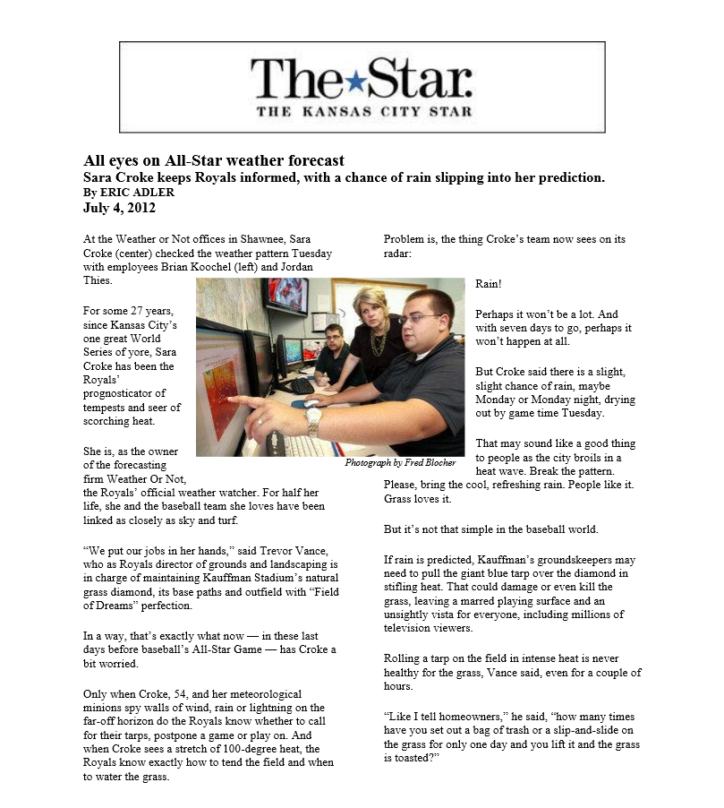
Is productivity as important to your business as the All-Star Game was to Kauffman Stadium?
Read the Kansas City Star article below which tells how Weather or Not saves money and improves safety for businesses, international airports and a Major League Ball Club.
 Put Your Business On Our Radar – Contact Us Today!
September 8, 2014
The Midwest in is the throws of a significant pattern change that will mark the arrival of Fall. After a brief return to the 90s last week, a strong cold front and a Canadian high pressure system knocked the region back to near or slightly below normal for what turned out to be a beautiful weekend. This week, temperatures will warm slightly ahead of an even stronger cold front, then drop well-below normal.
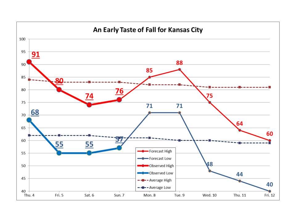
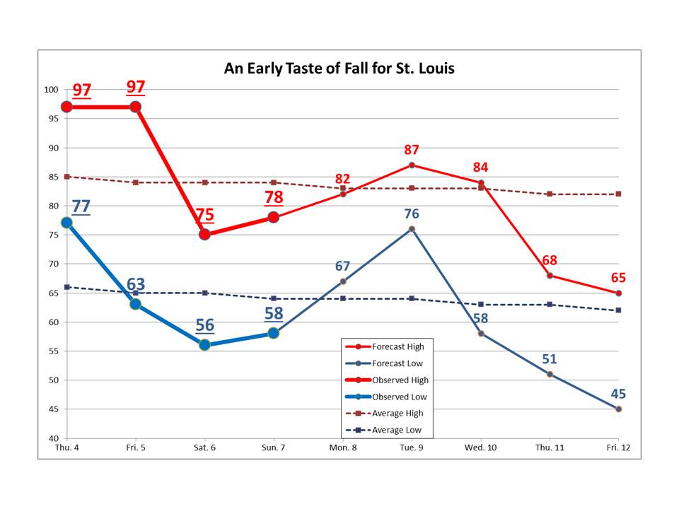
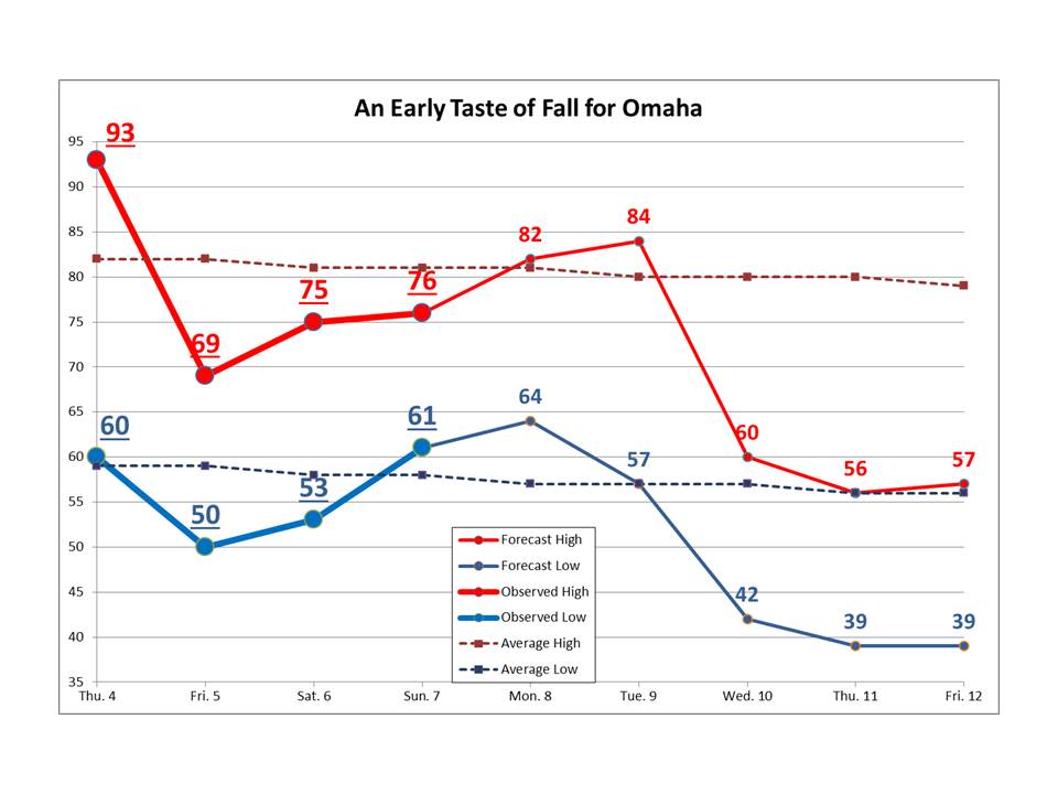
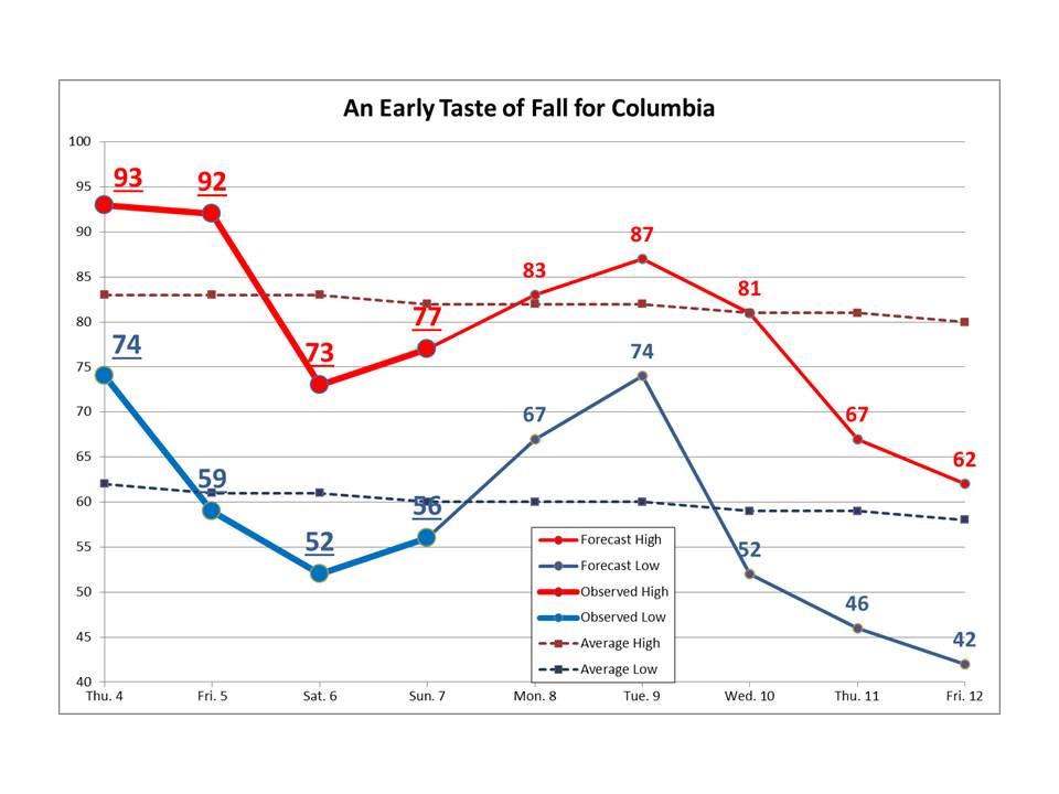
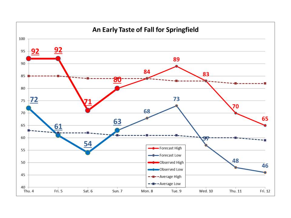
Depending on cloud cover and winds, overnight lows could drop into the upper 30s and low 40s! The outlook for the next couple of weeks does not show any sign of summer heat and humidity making a comeback.
August 8, 2014
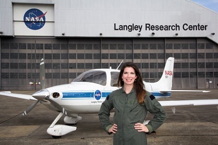
Good luck summer intern Hallie Dusselier!
Hallie graduated from Creighton University in June and is starting her Master’s work at Ohio University. She has been awarded a research grant in Arctic Climatology.
Congratulations to last summer’s intern Laren Mahoney!
This summer – NASA intern – This fall, Claire Booth Luce Women’s Fellowship – Creighton University Masters program.
Want to be one of the “cool kids”?
Contact us regarding internships available now:
August 7, 2014
The active weather pattern from last winter – dry for a few days then wet for a few days – has never really gone away. Sure, we recently went over 2 weeks without rain, but even that isn’t very long for a Midwest summer. August shows more of the same.

The broken record…..that is our weather pattern continues to spin. Through mid-August, expect multiple chances for rain and thunderstorms across the Central United States. The wettest period with above average precipitation anticipated will be today through Sunday and again around the 17th-19th with the next frontal passage.

As we head into early next week we’ll see the ridge across the Western Untied States amplify, deepening the trough. This means that the pesky northwest flow will continue, allowing us to see several chances for showers or thunderstorms. Just like winter, any disturbances coming through the northwest flow tend to be weak with limited chances for more isolated rain. Between the 17th-19th a frontal boundary will push through the Central Plains improving the opportunity for showers & storms. While this rain event may not be as abundant as earlier in the month, it is the next most likely widespread rain event. High pressure will then move in from the north with dry conditions and average to above average temperatures.

July 14, 2014
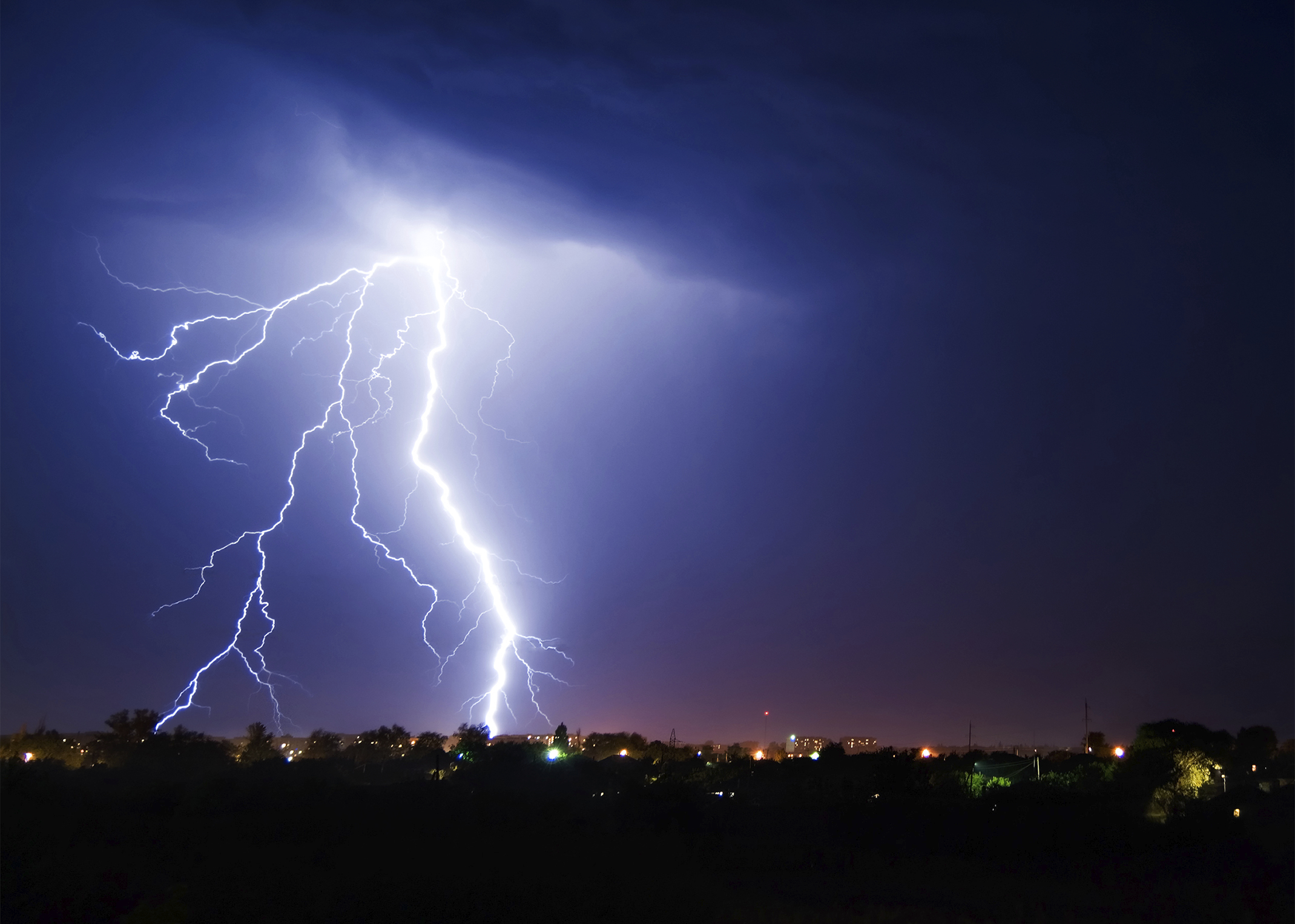 Tragedy struck this weekend in Rocky Mountain National Park as two separate lightning strikes, just 24 hours apart, claimed two lives and injured others. Unfortunately, this kind of incident is not as unusual as one would think with over 30% of all lightning fatalities occurring in the month of July, according to the National Weather Service.
Does Your Lightning Safety Plan include at least the following?
Weather or Not is proud that our clients took the time to iron out these details before the storm season began.
We have partnered with Earth Networks, the world’s leaders in lightning detection and alerting, to add to our suite of emergency preparedness and up-to-the-minute weather consulting.
(Contact our experts) to help you keep your patrons and staff safe during this unusually active, stormy summer.
Below is an example of a typical radar image that you will see on your computer, tablet or smart phone. You can see the characteristic light to dark green values indicating the radar is detecting precipitation, or is it?

Kansas City Base Reflectivity
With dual-pol radar products, meteorologists have additional data to differentiate radar echoes that are caused by precipitation versus echoes that can be caused by insects, birds, smoke, etc.

Kansas City Dual-Pol Radar – Correlation Coefficient
We’ve highlighted the area of interest below which shows light and dark greens that appear to be precipitation at first, however they are actually non-meteorological, meaning it isn’t actually rain!
 Reflectivity – Highlighted |
 Correlation Coefficient – Highlighted |
Just another reason why you can’t always trust what the radar is telling you!


 Tell our meteorologists what weather answers you need to improve profits and safety where you work.