2012 APWA Snow Training Expo

October 10, 2012


Training professionals improves efficiency and expertise. It’s the best way to save money and improve safety. That’s why cities and counties throughout the region sent their drivers to the 25th Annual Snow and Equipment Training Expo last week. It’s an excellent investment!


Fall Foliage

October 8, 2012

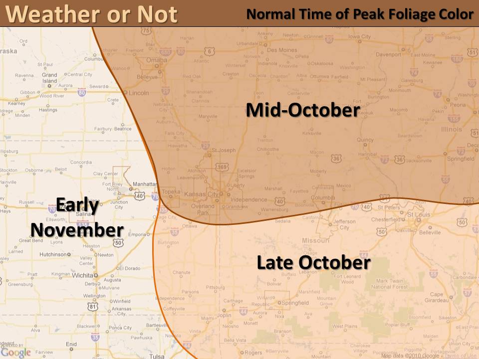
Fall foliage is already in full swing across the Northeastern United States, while signs of change are beginning to show up in the Midwest. The typical peak for Fall colors occurs in October, however some areas to the west won’t see their peak until early November.

Normal Time for Peak Foliage Color

Normal Time for Peak Foliage Color

Temperature and soil moisture play a large role in the vibrancy of fall colors.  Warm sunny days followed by cool nights bring the most colorful leaves. These conditions allow the leaves to slowly become dormant,  bringing out the most colorful foliage.  The amount of soil moisture also affects the onset and amount of color seen, with adequate soil moisture providing optimum color.

What can we expect for color this year?

Recent warm days and cool nights have allowed some decent colors to appear in northwestern Missouri.  However, with the lack of soil moisture caused by this summer’s drought we can expect “leaf peaking” to be less intense this fall.


Track Fall Foliage in Missouri –  Missouri Department of Conservation

Read about Fall Colors in Nebraska – Nebraska Games & Parks Commission

Weekly Updates on Foliage in Iowa – Iowa Department of Natural Resources


Dramatic Change!

October 5, 2012

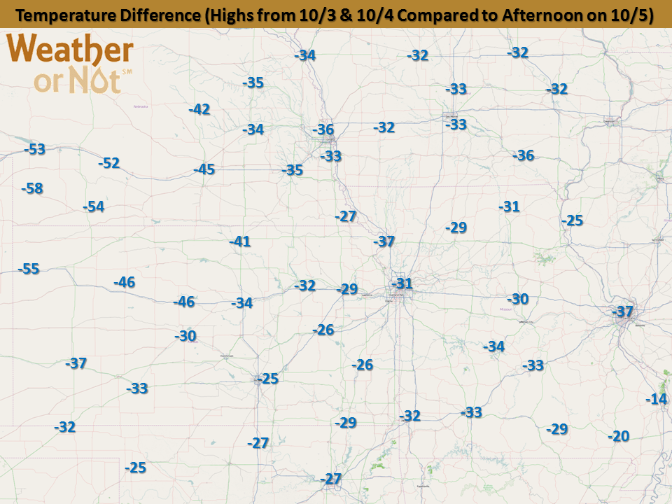
Earlier this week the Central Plains were basking in mild temperatures for early October with highs in the upper 70s to lower 90s!  Now, just one or two days later we have areas of snow and temperatures struggling to reach 50 degrees.  This dramatic change was thanks to a strong cold front that moved across the Central Plains and even into the southern United States.  Take a look below to see just how far those temperatures fell with a comparison of highs on Wednesday or Thursday to the afternoon on Friday.

 Temperature Difference (10/3-4 to 10/5)


Roost Rings

The Kansas City National Weather Service Radar picked up an interesting phenomena on radar this morning over northern Missouri, a roost ring!  Check out the animated image below which shows the radar from 6:47am until 7:42am and focus in on the area northeast of Carrollton, Missouri.

The expanding circular object is actually flocks of birds leaving their overnight stay in local conservation areas, including Fountain Grove, Yellow Creek and Pershing State Park.  A cool phenomena that shows radar doesn’t show you just precipitation!


How reliable are your emergency communication methods?

September 26, 2012

Clear communications are critical to managing emergencies.  Earlier this year, Weather or Not owner Sara Croke co-wrote a very informative article for the APWA Reporter (read more) about the reliability of different communication tools and how first responder’s should be prepared to have redundancy built into their communication plan during the course of a disaster.

What about your small business?  Your communication plan needs to be very comprehensive and far reaching too.  First and foremost your communication plan should include a strategy to communicate with your employees and their families.  From that point, your list of audiences cover a large group of people and each of these groups will need to be addressed during the course of an emergency.


(Courtesy of FEMA)

For more information about developing your plan contact Weather or Not President, Sara Croke.  Sara will speak with your managers about how to develop a plan for your specific business needs.  Call 913-722-3955 or 800-996-7668 today, so your business is ready when the next disaster strikes.


The First Freeze of Fall 2012

September 21, 2012

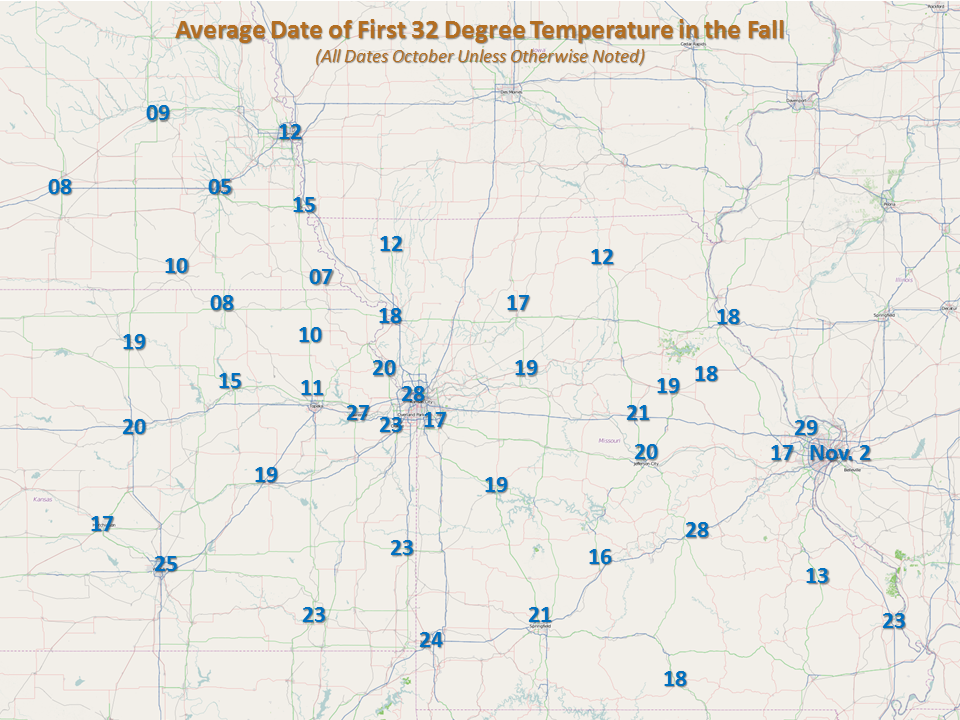
While it won’t happen tonight, freezing temperature are inevitable. Fall may just be starting, so patchy frost is not far behind, and eventually a widespread freeze to plants will occur.  Temperatures will often cool faster in low-lying areas and river valleys, where the denser cold air can settle into these lower terrains.  You will also see the first frost and freeze come to rural areas or outskirts of urban areas before the densely populated urban areas.  When can you expect that mercury to drop to 32 degrees?

Average Date of First Freeze

Average Date of First Fall Freeze


Follow along when areas see their first freeze with this map courtesy of the Midwestern Regional Climate Center.  The map will update each morning to show the progression of freezing temperatures.

Date of First Fall Freeze of 2012

Date of First Fall Freeze of 2012

Check back to the Weather or Not Blog to see when freezing invades from Canada!


Ranking the Summer of 2012

September 17, 2012


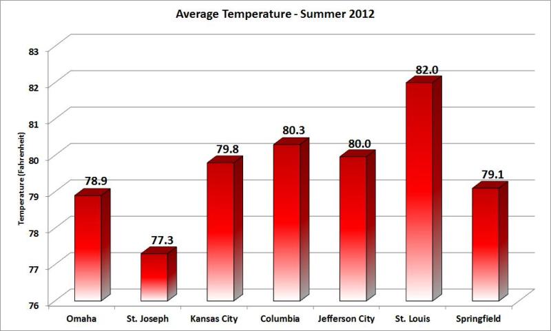
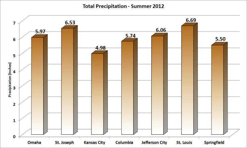
Hot and dry.  Just how hot and how dry was the meteorological summer (June-August) of 2012?  Where does it rank?  Take a look below to find out.
Average Temperature - Summer 2012

Average Temperature – Summer 2012


In Omaha, the average temperature of 78.9 degrees made it the 3rd warmest summer on record while 5.97″ of rain made it the 10th driest as well.  This summer isn’t the only season that has been warm though, Omaha is currently having their warmest year to date and had the warmest March-August on record!  Over the summer they set 6 daily maximum temperature records and 4 daily high minimum record (warmest low).

Kansas City had the 16th warmest summer on record with an average temperature of 79.8 degrees, which isn’t quite as warm that most would have anticipated.  Ironically, the average high temperature of 92.6 degrees, ranks 5th warmest on record.  Meanwhile, the average low temperature of 66.9 degrees ranks 75th warmest!  You can see that the cool nights helped this summer to not reach the top 10 in terms of warmest average temperature.  The 4.98 inches of precipitation this summer ranks it as the 6th driest on record.  There were 3 daily maximum temperatures, 2 daily record minimum temperatures tied or broken.

For Columbia the average temperature this summer was 80.3 degrees which is 6th warmest on record, the average high temperature this summer was 93.6 degrees!  This summer recorded 5.74 inches of precipitation in Columbia, which ranked as the 9th driest on record.  Over the months of June, July and August Columbia had quite the heat wave, recording 27 consecutive days of 90 degrees or warmer (tied 2nd longest streak) and had 10 days of 100 degrees or warmer (6th longest streak).  There were 6 daily maximum temperature records set, 1 record high minimum and 1 record daily rainfall.
Precipitation - Summer 2012

Precipitation – Summer 2012

St. Louis (Lambert International Airport) had its 4th warmest summer on record with an average temperature of 82 degrees.  The average high temperature for the summer was 93.1 degrees, while the average low was 70.8 degrees.  The 6.69 inches of precipitation this summer ranks as the 21st driest on record, with 1.48 inches coming on the final day of meteorological summer (August 31).  Some of the notable records this summer included the most days with a high of 105 degrees or higher, 3rd most days with a temperature of a 100 degrees or higher and the most occurrences of a low temperature being 85 degrees or warmer.  St. Louis had 11 record daily maximum temperatures, 7 record high minimum temperatures and 1 daily maximum rainfall.

Springfield had an average temperature of 79.1 degrees, putting this summer in a tie for 9th warmest on record.  Springfield received 5.50 inches of rain this summer, 4.01 inches came in August alone after the driest July on record (0.32 inches).  Over the course of the summer Springfield set 7 daily high temperature records and tied 6 more while also setting a record high temperature for the month of June at 101 degrees.


Missouri Spells Relief: I-S-A-A-C

September 6, 2012

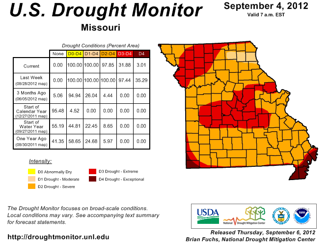
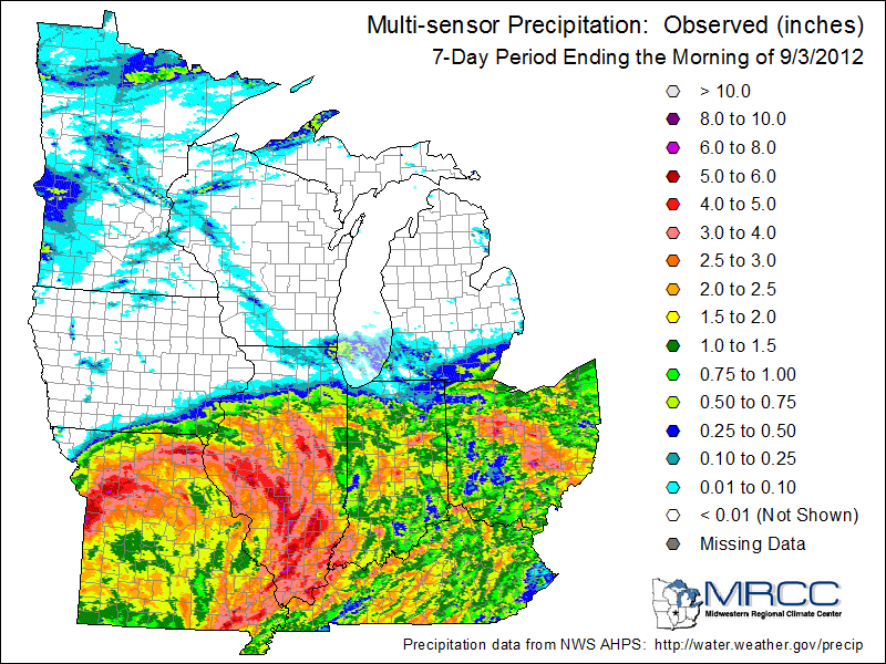
Released this morning, the National Drought Monitor downgraded most of Missouri from either “extreme” or “exceptional” to “severe” drought.  The remnants of Hurricane Isaac provided much needed relief!

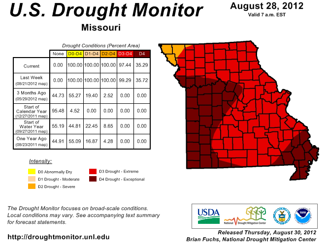
Missouri Drought Monitor - August 28

Missouri Drought Monitor – Aug. 28, 2012

Missouri Drought Monitor Sept. 6, 2012

Dragging northward, this tropical air mass brought significant rainfall to the entire state with totals ranging from 1.43″ in Farmington, MO to 6.52″ in Edina, MO. The deluge felt by many over the weekend was enough to take a major bite out of our rainfall deficits. However, the drought monitor shows we still have a way to go before total relief is felt.


Some of the winners in the rainfall lottery were:

Edina – 6.5 inches

Independence – 6.2

Lee’s Summit – 5.6

Mexico – 5.2 inches

Kansas City DT – 4.9

Centralia – 4.7 inches

Fenton – 3.4 inches


September is National Disaster Preparedness Month

September 4, 2012

Did hurricanes prompt the choosing of September as National Preparedness Month?  Actually, the tragedy of 9/11 reminded us all that survival preparations could be needed at a moment’s notice.

Improving disaster preparedness and response is the purpose of the 9th Annual National Preparedness Month.


Pledge to Prepare:  Awareness to Action

  1. Develop a communications plan.
  2. Learn about emergency hazards and appropriate responses.
  3. Build an emergency kit.
  4. Get involved in preparedness in your community

Throughout September, we will be sharing emergency preparedness lessons learned that will help your operation be ready for the next disaster. We would like to hear your strategies or answer your questions. Please leave us a comment or e-mail us!


Will Isaac Bring Relief from Drought?

August 30, 2012


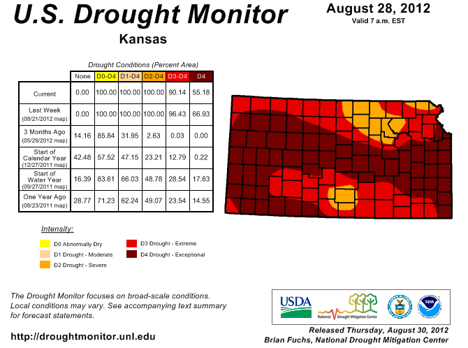
Released this morning, the latest drought monitor shows slight improvement to Central Kansas and the Northwest corner of Missouri.  These areas went from extreme to severe drought.  Elsewhere, the impact of the rain last weekend left drought conditions unchanged.  ALL could use days of steady rain.


Related:  Exceptional Drought? How do they decide?


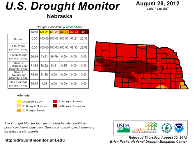
Does Isaac spell R-E-L-I-E-F?  The latest forecast analysis shows that areas of Missouri, adjacent portions of Arkansas, and the Mississippi River Valley could be in line for significant rainfall from the remnants of now Tropical Storm Isaac.  Will it be enough to end the drought?  Look closely at the latest drought monitor maps below and see what category of drought you are currently in.


Kansas Drought Monitor - August 28

Kansas Drought Monitor

Missouri Drought Monitor - August 28

Missouri Drought Monitor

Nebraska Drought Monitor - August 28

Nebraska Drought Monitor


If you are in the exceptional drought that encompasses such areas as Kansas City, Columbia or Joplin, you will need at least 9 inches of rainfall to alleviate the drought conditions to the point of being only abnormally dry.  Some of those areas actually need in excess of a foot of rain to improve conditions to being only abnormally dry.  Those in the severe drought category, will need at least 6-10 inches of rainfall to alleviate drought conditions.  On Isaac’s current trajectory, a few isolated areas of Missouri and adjacent areas may be able to approach those critical values.

It’s a tough year when hopes for rain hang on a hurricane.  Unfortunately for the Midwest, no other sustained wet pattern is predicted at this time.