The Big Chill Moves Through

Ride along the cold front as it passed through the Central United States this weekend.  We went from t-shirts to turtlenecks as temperatures dropped 50 degrees in some cities. The nose diving temperatures were accompanied by rain and gusty winds making for a very raw time.

Follow the front from northwest to southeast, as it dramatically drops temperatures first in Salina and Omaha, then Topeka and Kansas City, through Mid-Missouri and Springfield, before finally pushing through St. Louis.


Ranking the Summer of 2012

September 17, 2012


Hot and dry.  Just how hot and how dry was the meteorological summer (June-August) of 2012?  Where does it rank?  Take a look below to find out.

Average Temperature - Summer 2012

Average Temperature – Summer 2012


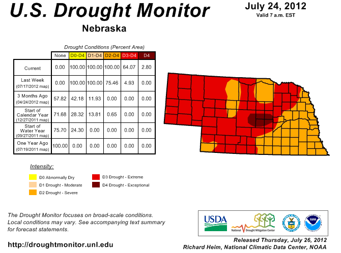
In Omaha, the average temperature of 78.9 degrees made it the 3rd warmest summer on record while 5.97″ of rain made it the 10th driest as well.  This summer isn’t the only season that has been warm though, Omaha is currently having their warmest year to date and had the warmest March-August on record!  Over the summer they set 6 daily maximum temperature records and 4 daily high minimum record (warmest low).

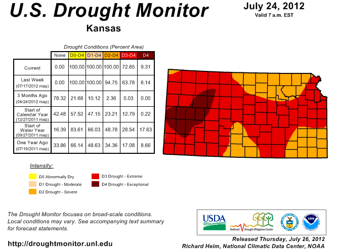
Kansas City had the 16th warmest summer on record with an average temperature of 79.8 degrees, which isn’t quite as warm that most would have anticipated.  Ironically, the average high temperature of 92.6 degrees, ranks 5th warmest on record.  Meanwhile, the average low temperature of 66.9 degrees ranks 75th warmest!  You can see that the cool nights helped this summer to not reach the top 10 in terms of warmest average temperature.  The 4.98 inches of precipitation this summer ranks it as the 6th driest on record.  There were 3 daily maximum temperatures, 2 daily record minimum temperatures tied or broken.

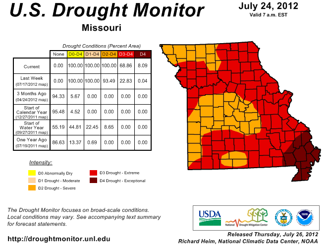
For Columbia the average temperature this summer was 80.3 degrees which is 6th warmest on record, the average high temperature this summer was 93.6 degrees!  This summer recorded 5.74 inches of precipitation in Columbia, which ranked as the 9th driest on record.  Over the months of June, July and August Columbia had quite the heat wave, recording 27 consecutive days of 90 degrees or warmer (tied 2nd longest streak) and had 10 days of 100 degrees or warmer (6th longest streak).  There were 6 daily maximum temperature records set, 1 record high minimum and 1 record daily rainfall.

Precipitation - Summer 2012

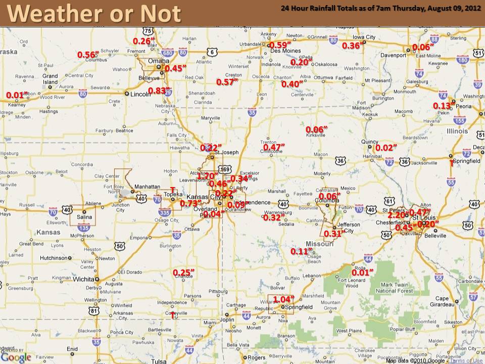
Precipitation – Summer 2012

St. Louis (Lambert International Airport) had its 4th warmest summer on record with an average temperature of 82 degrees.  The average high temperature for the summer was 93.1 degrees, while the average low was 70.8 degrees.  The 6.69 inches of precipitation this summer ranks as the 21st driest on record, with 1.48 inches coming on the final day of meteorological summer (August 31).  Some of the notable records this summer included the most days with a high of 105 degrees or higher, 3rd most days with a temperature of a 100 degrees or higher and the most occurrences of a low temperature being 85 degrees or warmer.  St. Louis had 11 record daily maximum temperatures, 7 record high minimum temperatures and 1 daily maximum rainfall.

Springfield had an average temperature of 79.1 degrees, putting this summer in a tie for 9th warmest on record.  Springfield received 5.50 inches of rain this summer, 4.01 inches came in August alone after the driest July on record (0.32 inches).  Over the course of the summer Springfield set 7 daily high temperature records and tied 6 more while also setting a record high temperature for the month of June at 101 degrees.


Will Isaac Bring Relief from Drought?

August 30, 2012


Released this morning, the latest drought monitor shows slight improvement to Central Kansas and the Northwest corner of Missouri.  These areas went from extreme to severe drought.  Elsewhere, the impact of the rain last weekend left drought conditions unchanged.  ALL could use days of steady rain.


Related:  Exceptional Drought? How do they decide?


Does Isaac spell R-E-L-I-E-F?  The latest forecast analysis shows that areas of Missouri, adjacent portions of Arkansas, and the Mississippi River Valley could be in line for significant rainfall from the remnants of now Tropical Storm Isaac.  Will it be enough to end the drought?  Look closely at the latest drought monitor maps below and see what category of drought you are currently in.


Kansas Drought Monitor - August 28

Kansas Drought Monitor

Missouri Drought Monitor - August 28

Missouri Drought Monitor

Nebraska Drought Monitor - August 28

Nebraska Drought Monitor


If you are in the exceptional drought that encompasses such areas as Kansas City, Columbia or Joplin, you will need at least 9 inches of rainfall to alleviate the drought conditions to the point of being only abnormally dry.  Some of those areas actually need in excess of a foot of rain to improve conditions to being only abnormally dry.  Those in the severe drought category, will need at least 6-10 inches of rainfall to alleviate drought conditions.  On Isaac’s current trajectory, a few isolated areas of Missouri and adjacent areas may be able to approach those critical values.

It’s a tough year when hopes for rain hang on a hurricane.  Unfortunately for the Midwest, no other sustained wet pattern is predicted at this time.

Why Soakers Missed KC Saturday Night

Sunday, August 26, 2012

A slow-moving storm brought soaking rainfall to the Central Plains over the last few days.  Topeka recorded a daily record of 2.55” of rain for August 25th. Milford Kansas, just west of Manhattan, recorded a whopping 6.01” of rain from this storm!

1-2 inches of rainfall looked like a good bet for Kansas City Saturday night.  Many lawns were eagerly awaiting a good drink of H20, but it didn’t happen for Kansas City.

The radar screenshot from ~7pm Saturday evening (left-below) shows widespread thunderstorms developing west and southwest of Kansas City.  An increase in winds just above the surface along with a warm, moist fetch of air from the Gulf of Mexico was expected to sustain the storms as they moved into the area. Taking a closer look, you can see a cluster of thunderstorms ahead of the main rain band straddling the Kansas/Oklahoma border.  Thunderstorms had been moving northeast throughout the day, which is why Kansas City had good reason to be hopeful.


Regional Radar - August 25, 2012 at 6:59pm

Regional Radar 6:59pm

Regional Radar - August 25, 2012 at 10:00pm

Regional Radar 10:00pm


The next radar screenshot (right-above) is just three hours later at 10pm. The cluster of thunderstorms that was along the border raced eastward into Missouri. This cut off our supply of moisture and dashed any hope of significant rainfall.  Unfortunately, this created a void over Kansas City as shown below.


Storm Total Precipitation through 12pm August 26, 2012

Storm Total Precipitation

Much Needed Rain for Central Plains

Saturday, August 25

It has been at least 65 days since any of the locations listed below have had an inch or more rain in a single day.  For Kirksville, Missouri it has been a whopping 134 days!

While areas of Kansas and northwest Missouri have already seen significant rain, for the rest of Missouri it brings up an interesting question.

When was the last time it rained an inch in a single day?


Kirksville, MO –  April 13
Sedalia, MO –  April 29
Joplin, MO –  May 31
St. Louis, MO –  June 11
Kansas City International –  June 11
Downtown Kansas City –  June 11
St. Joseph, MO –  June 11
Columbia, MO –  June 16
Jefferson City, MO –  June 16
Chillicothe, MO –  June 16
Olathe, KS –  June 21
Lee’s Summit, MO –  June 21


Recipe for Record Lows

August 20, 2012

Low dewpoints, clear skies and light winds were the perfect recipe for record low temperatures this weekend. Let’s take a look at how each of these factors contributed to some cool mornings…

START WITH – Low Dewpoints: The dewpoint is a measure of the amount of moisture in the atmosphere. When dewpoints climb above 60 degrees in the summer, the air feels warm and muggy. Warm dewpoints on a summer night also limit cooling. This is because as the air temperature gets close to the dewpoint, relative humidity increases and condensation occurs. The process of condensation releases heat into the air causing the temperature to level-off near the dewpoint. So when the dewpoint is lower, that “level-off” happens at a lower temperature. That was the case this weekend as dewpoints dropped into the 40s.

ADD IN – Clear Skies: Starry skies are needed for temperatures to fall close to the dewpoint. During the day pavement, buildings, vegetation and soil absorb heat from the sun. During the night, that heat gets released back toward space. When the nighttime sky is cloudy, those clouds act like a blanket at night, keeping temperatures warm. However, when the nighttime sky is clear, heat released from earth escapes into space causing temperatures to drop. Locations that saw record lows this weekend all had clear skies for a majority of the night.


In winter, we welcome the cloudy blanket for warmth.

MIX WITH – Light Winds: Wind speed is the final factor in how low temperatures can fall. Since air normally cools from the ground up, the air closest to the ground is the coolest overnight. As you increase in elevation off the ground, the temperature normally gets warmer. If the wind is strong overnight, the cool air near the surface mixes with the warmer air above, which limits the potential for cooling. However, on a night with light winds, the air near the ground continues to cool with no influence from warm air above. Wind speeds were generally less than 5 mph this weekend.

Please Sir, May We Have Some More…..Lots More?

August 9, 2012

Rumbles of thunder and the pitter-patter of rain last night brought hope to many across the area.   The biggest smiles were found in St. Charles, MO  where they saw over two inches of rain!  However, most of us felt teased as it barely settled the dust.

8-8

How much will it take to really make a difference?

A whole lot more than just normal precipitation is needed, especially in the Central Plains. An occasional inch or two of rain might green up your brown, crunchy lawn, but it will do little to regenerate your local water shed.   An extended period of above normal precipitation is needed to chip away at the deficit and restore the water supply.

Additional Precipitation Needed


July 2012: Record Breaking!

Most people across the region came to the conclusion that July was hot and dry, however just how hot and how dry?  We have gathered data for several cities across the area, finding the Top 10 hottest and Top 10 driest Julys on record. Each city had a July average temperature that ranked in the Top 10, with St. Louis having the hottest July on record.  While it was also dry across the region, the precipitation numbers vary a lot more than temperature as isolated thunderstorms provided hit and miss rainfall.  For example, Omaha managed to have their driest July on record with only 0.01″ of precipitation, which also ranks as their sixth driest month ever!  Meanwhile, Columbia managed to see a few of those hit and miss thunderstorms, which led to 1.56″ of precipitation, making it their 26th driest July.  Check out how your city ranks with the graphs below:


Omaha, NE

St. Joseph, MO

Kansas City, MO

Columbia, MO

St. Louis, MO

Springfield, MO

Drought Monitor (July 24, 2012)

July 26, 2012

The latest drought monitor has been released and the Central Plains saw conditions slightly worsen over the past week.  Although there was some rainfall that occurred this morning across the area, the latest update only includes precipitation through 6am CST on July 24.  The contiguous United States has just over 80% of the county with abnormally dry or worse conditions, a whopping 63.9% actually in some form of drought.  To make matters worse, over 20% of the country is in extreme or exceptional drought, first time since mid-February 2003.  Below is a closer look at individual states:


Nebraska

100% of the state is in severe or worse drought with a majority (64%) actually in extreme or worse.  Eastern Nebraska has managed some rain recently which has provided it with slightly better conditions, while the central portion of the state sees the first exceptional drought rating for Nebraska since July of 2004.  Like many other states, three months ago there was a single acre in Nebraska being designated in severe or worse drought, indicating just how quickly the lack of rainfall has built up.


Kansas

Kansas also has 100% of the state in severe or worse drought conditions with the latest drought update, and a large majority (over 72%) in extreme or exceptional drought.  Extreme drought covers much of western Kansas and extends across portions of the entire state, including the metro areas of Wichita, Topeka and the Kansas City area.  While less than a year ago there was nearly 18% of the state in exceptional drought compared to the current 9% the difference lies in the sheer expansive nature of this drought, only 75% of the state was in a form of drought then.


Missouri

As you could have expected, Missouri is another one of the four states that has 100% of their area in severe or worse drought (Iowa is the other along with Kansas and Nebraska).  The southeast portion of the state is hardest hit, where parts of 11 counties have been designated in exceptional or worse drought.  Extreme drought covers a large portion of the state, including the St. Louis Metro, Kansas City Metro and the cities of Springfield, Columbia and many more.  The cities of Jefferson City and Joplin are currently designated in only severe drought, however with little rain in sight for the next week they could see the extreme category in the next update.