Please Sir, May We Have Some More…..Lots More?

August 9, 2012

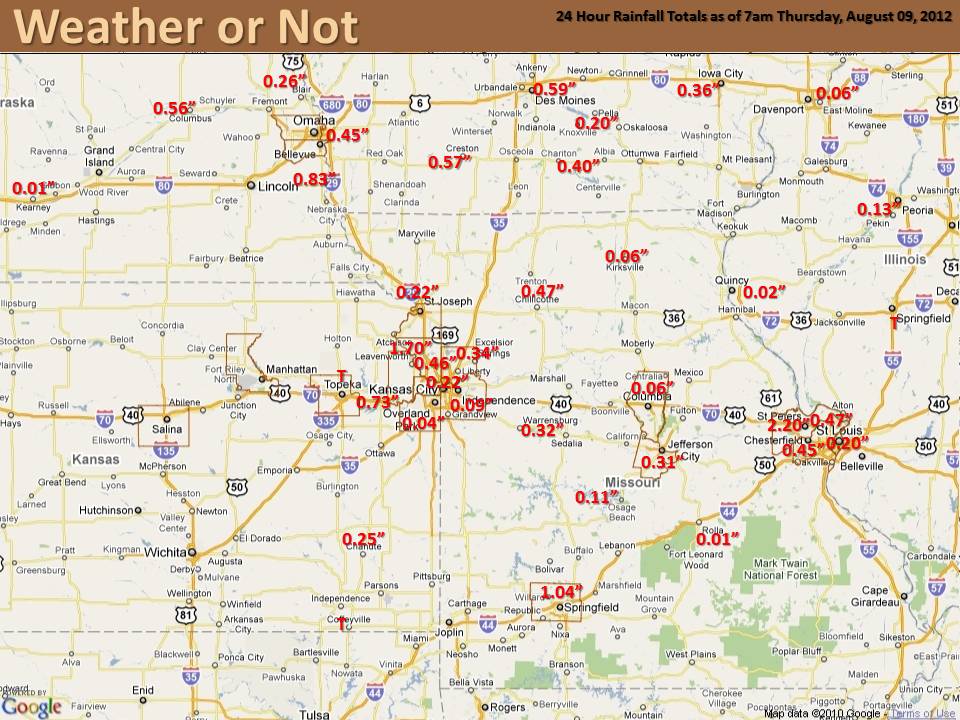
Rumbles of thunder and the pitter-patter of rain last night brought hope to many across the area.   The biggest smiles were found in St. Charles, MO  where they saw over two inches of rain!  However, most of us felt teased as it barely settled the dust.

8-8

How much will it take to really make a difference?

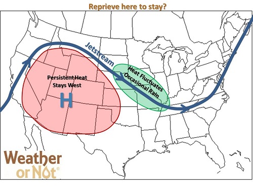
A whole lot more than just normal precipitation is needed, especially in the Central Plains. An occasional inch or two of rain might green up your brown, crunchy lawn, but it will do little to regenerate your local water shed.   An extended period of above normal precipitation is needed to chip away at the deficit and restore the water supply.

Additional Precipitation Needed


Is the Reprieve Here to Stay?

August 6, 2012

Expected Pattern 8-5

While rejoicing about this morning (lows 56 to 68), many are asking, will the persistent heat return? Thankfully, the answer is not yet. Earlier indications were that the scorching heat would return for the 10th through the 15th, but some welcome changes have occurred. Models now agree that the hot dome of high pressure stays west of the area, at least through the middle of next week. This means multiple cold fronts for the Missouri River Valley. Highs will climb above 90 ahead of the fronts, and drop below 90 behind the fronts, with no persistent 100+ stretches in sight. We look forward to occasional rain chances; not drought busting rains, but certainly welcome nonetheless. The jury is still out on the second half of the month. With the drought continuing, another heat wave could certainly be in store, but for now, watch for more pleasant days ahead!


8-5

July 2012: Record Breaking!

Most people across the region came to the conclusion that July was hot and dry, however just how hot and how dry?  We have gathered data for several cities across the area, finding the Top 10 hottest and Top 10 driest Julys on record. Each city had a July average temperature that ranked in the Top 10, with St. Louis having the hottest July on record.  While it was also dry across the region, the precipitation numbers vary a lot more than temperature as isolated thunderstorms provided hit and miss rainfall.  For example, Omaha managed to have their driest July on record with only 0.01″ of precipitation, which also ranks as their sixth driest month ever!  Meanwhile, Columbia managed to see a few of those hit and miss thunderstorms, which led to 1.56″ of precipitation, making it their 26th driest July.  Check out how your city ranks with the graphs below:


Omaha, NE

St. Joseph, MO

Kansas City, MO

Columbia, MO

St. Louis, MO

Springfield, MO

No Real Break in Sight

July 31, 2012


Occasional showers bring cloudy relief to a lucky few this week, but where the sun’s shining, temperatures continue climbing. This pattern is slightly nicer than the pattern we’ve seen so far this summer, with the ridge displaced slightly west. This keeps the hottest and driest weather just west of the Missouri River Valley.  As disturbances form over the Desert Southwest, they can climb up and over the ridge, spilling occasional rain chances into our area (ISO 1-1.5).  Unfortunately the lack of coverage and intensity of any rainfall continues to disappoint most thirsty lawns.

More widespread heat relief and rain chances arrive this weekend as another weak cold front moves through the region. The best potential to be closer to 90 than 100 should be the first day or two after the front passes. Then as the front retreats between the 6th-8th of August, there will likely be a gradual warm-up from west to east, with isolated rain chances continuing. After the 8th, the dome centers over us again causing the rain chances to decrease and heat to increase, with the next potential heat wave looming on the horizon sometime around the 10th-15th of August.  So, other than a few lucky locations, there are no signs of significant relief to the ongoing drought or sweltering summer heat.