Low Water on Mississippi River

In an ongoing saga between the drought and the Mississippi River, the Coast Guard and Army Corp of Engineers have been facing a constant battle in keeping the river open to boat and barge traffic.  The U.S. Coast Guard closed an 11-mile stretch of the river on Monday, August 20 after a ship ran aground while traveling near Greenville, Mississippi which has been closed intermittently since July.  Other portions of the river are staying open thanks to constant dredging.

A recent New York Times article spotlighted an individual dredge that is working just south of St. Louis.  The dredge Potter is said to be sucking up about 60,000 cubic yards of sediment from the bottom of the river and depositing it to the side.  The Potter is one of more than a dozen dredges out working on the river to keep traffic moving which is vital to the economy, with barges hauling grain, petroleum and coal among other products daily.  Inland waterways carry 60% of the nation’s grain exports, 22% of domestic petroleum and 20% of the coal used to generate electricity with a majority moving over the Mississippi and Ohio rivers.


How low is the Mississippi?

The river gauge at St. Louis has an observed value of -0.74 feet, 17th lowest on record (-6.10 feet on 01/16/1940 is record low).

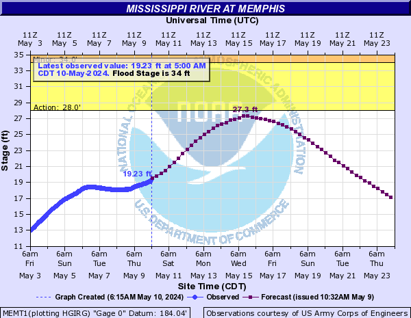
Memphis, Tennessee’s river gauge has an observed value of -8.73 feet, 4th lowest on record (-10.70 feet on 02/10/1937 is record low).

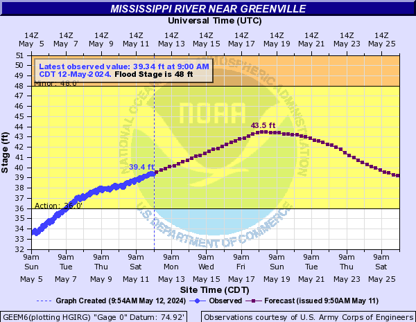
Greenville, Mississippi (near where the river has been closed) has a river level of 7.75 feet, 6th lowest on record (6.70 feet is record low on 01/04/1964).


Check out the hydrograph of each of those river gauges with the images below (will update automatically to the latest river levels).


St. Louis

St. Louis

St. Louis

Memphis

Greenville

Greenville

Recipe for Record Lows

August 20, 2012

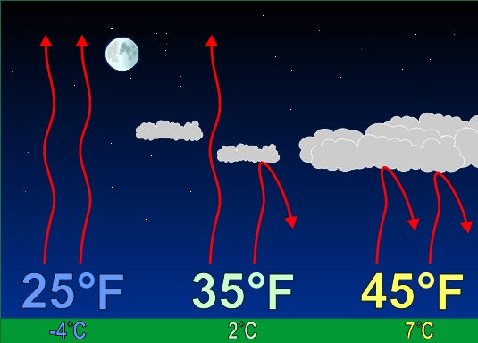
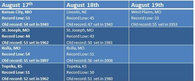
Low dewpoints, clear skies and light winds were the perfect recipe for record low temperatures this weekend. Let’s take a look at how each of these factors contributed to some cool mornings…

START WITH – Low Dewpoints: The dewpoint is a measure of the amount of moisture in the atmosphere. When dewpoints climb above 60 degrees in the summer, the air feels warm and muggy. Warm dewpoints on a summer night also limit cooling. This is because as the air temperature gets close to the dewpoint, relative humidity increases and condensation occurs. The process of condensation releases heat into the air causing the temperature to level-off near the dewpoint. So when the dewpoint is lower, that “level-off” happens at a lower temperature. That was the case this weekend as dewpoints dropped into the 40s.

ADD IN – Clear Skies: Starry skies are needed for temperatures to fall close to the dewpoint. During the day pavement, buildings, vegetation and soil absorb heat from the sun. During the night, that heat gets released back toward space. When the nighttime sky is cloudy, those clouds act like a blanket at night, keeping temperatures warm. However, when the nighttime sky is clear, heat released from earth escapes into space causing temperatures to drop. Locations that saw record lows this weekend all had clear skies for a majority of the night.


In winter, we welcome the cloudy blanket for warmth.

MIX WITH – Light Winds: Wind speed is the final factor in how low temperatures can fall. Since air normally cools from the ground up, the air closest to the ground is the coolest overnight. As you increase in elevation off the ground, the temperature normally gets warmer. If the wind is strong overnight, the cool air near the surface mixes with the warmer air above, which limits the potential for cooling. However, on a night with light winds, the air near the ground continues to cool with no influence from warm air above. Wind speeds were generally less than 5 mph this weekend.

July 2012: Record Breaking!

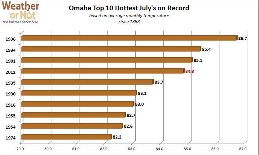
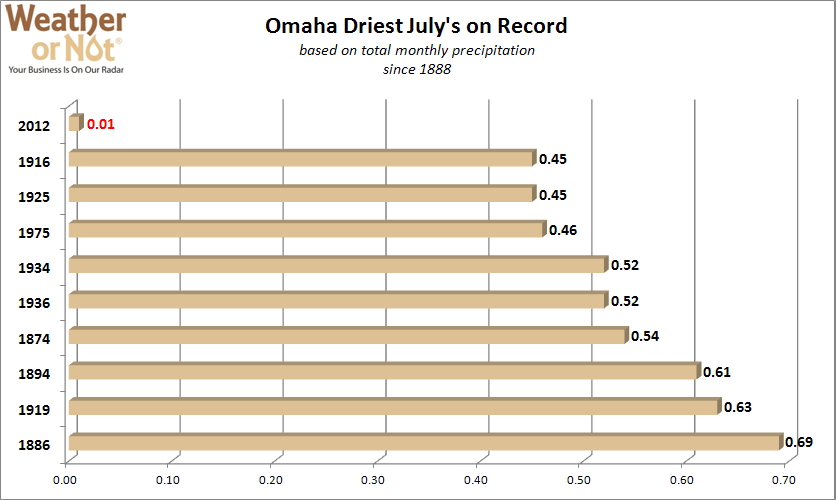
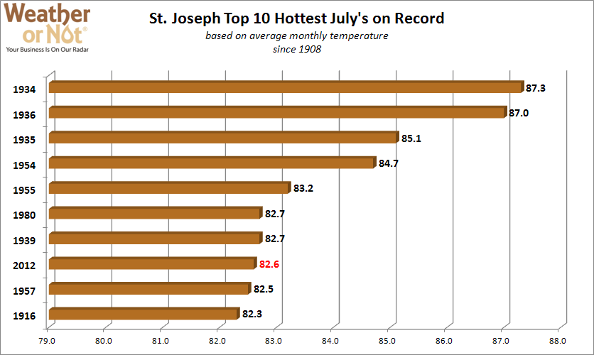
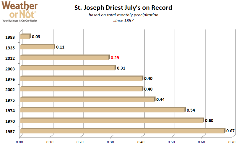
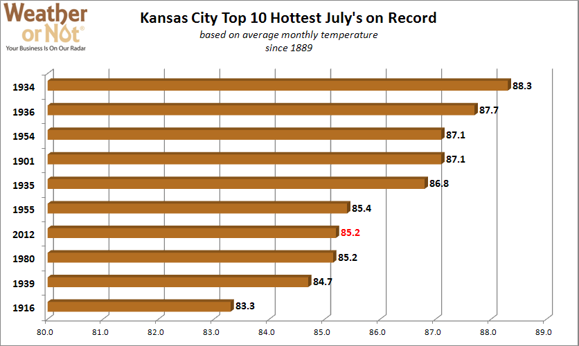
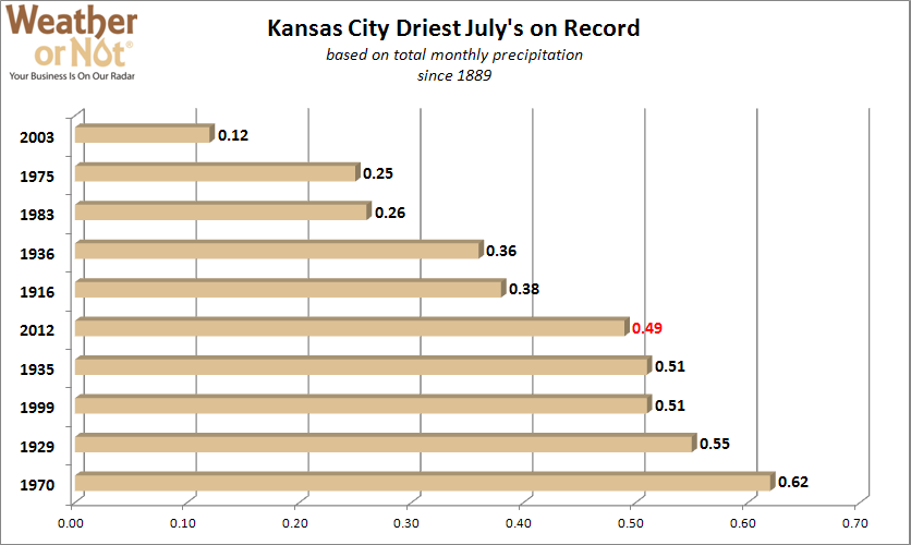
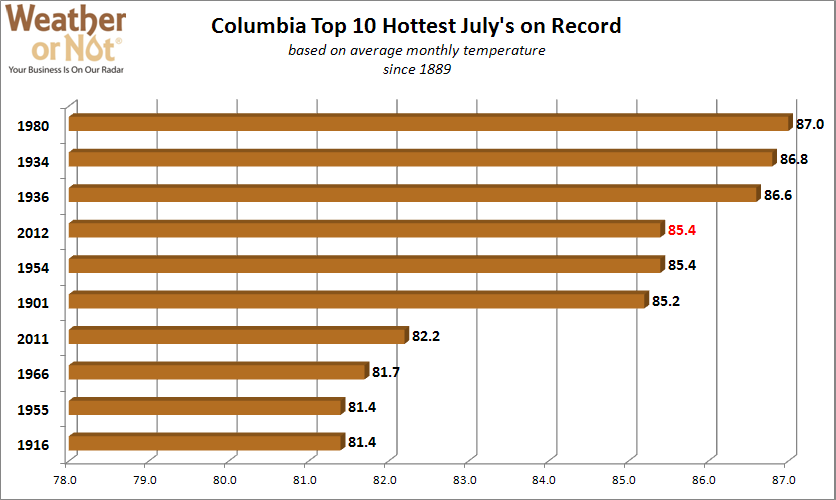
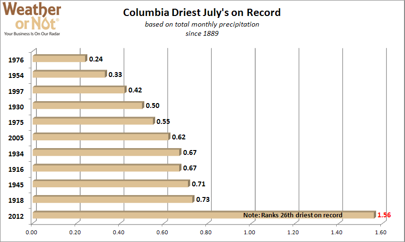
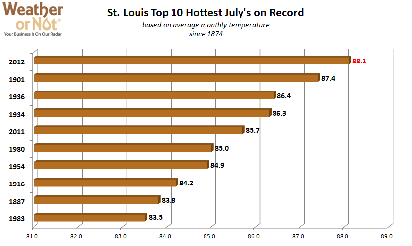
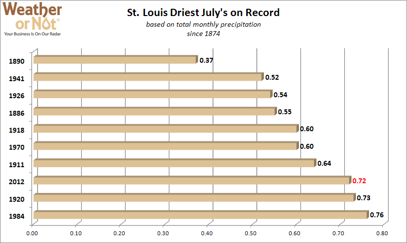
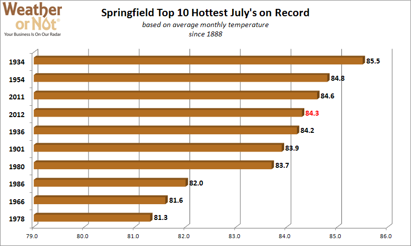
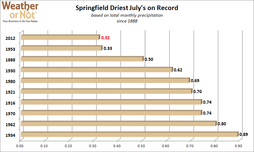
Most people across the region came to the conclusion that July was hot and dry, however just how hot and how dry?  We have gathered data for several cities across the area, finding the Top 10 hottest and Top 10 driest Julys on record. Each city had a July average temperature that ranked in the Top 10, with St. Louis having the hottest July on record.  While it was also dry across the region, the precipitation numbers vary a lot more than temperature as isolated thunderstorms provided hit and miss rainfall.  For example, Omaha managed to have their driest July on record with only 0.01″ of precipitation, which also ranks as their sixth driest month ever!  Meanwhile, Columbia managed to see a few of those hit and miss thunderstorms, which led to 1.56″ of precipitation, making it their 26th driest July.  Check out how your city ranks with the graphs below:


Omaha, NE

St. Joseph, MO

Kansas City, MO

Columbia, MO

St. Louis, MO

Springfield, MO