August 6, 2012
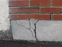
Water bills may be high, but never as costly as foundation repair. It is good to see a business do well, but do you want to be the contributor to their success?
If not, water your foundation!
August 6, 2012
Water bills may be high, but never as costly as foundation repair. It is good to see a business do well, but do you want to be the contributor to their success?
If not, water your foundation!
Most people across the region came to the conclusion that July was hot and dry, however just how hot and how dry? We have gathered data for several cities across the area, finding the Top 10 hottest and Top 10 driest Julys on record. Each city had a July average temperature that ranked in the Top 10, with St. Louis having the hottest July on record. While it was also dry across the region, the precipitation numbers vary a lot more than temperature as isolated thunderstorms provided hit and miss rainfall. For example, Omaha managed to have their driest July on record with only 0.01″ of precipitation, which also ranks as their sixth driest month ever! Meanwhile, Columbia managed to see a few of those hit and miss thunderstorms, which led to 1.56″ of precipitation, making it their 26th driest July. Check out how your city ranks with the graphs below:
Omaha, NE


St. Joseph, MO


Kansas City, MO


Columbia, MO


St. Louis, MO


Springfield, MO


July 31, 2012

Occasional showers bring cloudy relief to a lucky few this week, but where the sun’s shining, temperatures continue climbing. This pattern is slightly nicer than the pattern we’ve seen so far this summer, with the ridge displaced slightly west. This keeps the hottest and driest weather just west of the Missouri River Valley. As disturbances form over the Desert Southwest, they can climb up and over the ridge, spilling occasional rain chances into our area (ISO 1-1.5). Unfortunately the lack of coverage and intensity of any rainfall continues to disappoint most thirsty lawns.

More widespread heat relief and rain chances arrive this weekend as another weak cold front moves through the region. The best potential to be closer to 90 than 100 should be the first day or two after the front passes. Then as the front retreats between the 6th-8th of August, there will likely be a gradual warm-up from west to east, with isolated rain chances continuing. After the 8th, the dome centers over us again causing the rain chances to decrease and heat to increase, with the next potential heat wave looming on the horizon sometime around the 10th-15th of August. So, other than a few lucky locations, there are no signs of significant relief to the ongoing drought or sweltering summer heat.

July 26, 2012
The latest drought monitor has been released and the Central Plains saw conditions slightly worsen over the past week. Although there was some rainfall that occurred this morning across the area, the latest update only includes precipitation through 6am CST on July 24. The contiguous United States has just over 80% of the county with abnormally dry or worse conditions, a whopping 63.9% actually in some form of drought. To make matters worse, over 20% of the country is in extreme or exceptional drought, first time since mid-February 2003. Below is a closer look at individual states:
Nebraska
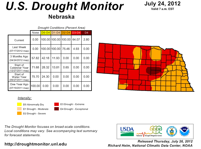
100% of the state is in severe or worse drought with a majority (64%) actually in extreme or worse. Eastern Nebraska has managed some rain recently which has provided it with slightly better conditions, while the central portion of the state sees the first exceptional drought rating for Nebraska since July of 2004. Like many other states, three months ago there was a single acre in Nebraska being designated in severe or worse drought, indicating just how quickly the lack of rainfall has built up.
Kansas
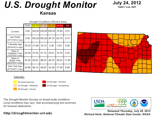
Kansas also has 100% of the state in severe or worse drought conditions with the latest drought update, and a large majority (over 72%) in extreme or exceptional drought. Extreme drought covers much of western Kansas and extends across portions of the entire state, including the metro areas of Wichita, Topeka and the Kansas City area. While less than a year ago there was nearly 18% of the state in exceptional drought compared to the current 9% the difference lies in the sheer expansive nature of this drought, only 75% of the state was in a form of drought then.
Missouri
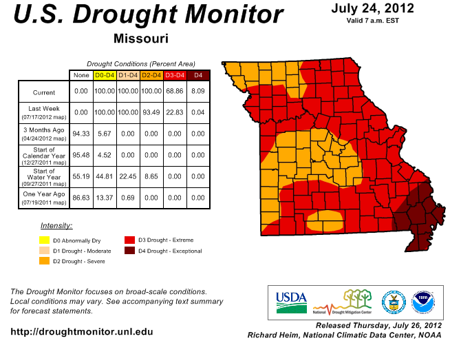
As you could have expected, Missouri is another one of the four states that has 100% of their area in severe or worse drought (Iowa is the other along with Kansas and Nebraska). The southeast portion of the state is hardest hit, where parts of 11 counties have been designated in exceptional or worse drought. Extreme drought covers a large portion of the state, including the St. Louis Metro, Kansas City Metro and the cities of Springfield, Columbia and many more. The cities of Jefferson City and Joplin are currently designated in only severe drought, however with little rain in sight for the next week they could see the extreme category in the next update.